| Arles-sur-Tech Arles | |
|---|---|
| Commune | |
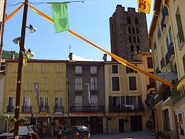
 Shops in Arles-sur-Tech, with the Tour Saint-Sauveur in the background Shops in Arles-sur-Tech, with the Tour Saint-Sauveur in the background | |
| Location of Arles-sur-Tech | |
  | |
| Coordinates: 42°27′27″N 2°38′04″E / 42.4575°N 2.6344°E / 42.4575; 2.6344 | |
| Country | France |
| Region | Occitania |
| Department | Pyrénées-Orientales |
| Arrondissement | Céret |
| Canton | Le Canigou |
| Intercommunality | CC du Haut Vallespir |
| Government | |
| • Mayor (2020–2026) | David Planas |
| Area | 28.82 km (11.13 sq mi) |
| Population | 2,794 |
| • Density | 97/km (250/sq mi) |
| Time zone | UTC+01:00 (CET) |
| • Summer (DST) | UTC+02:00 (CEST) |
| INSEE/Postal code | 66009 /66150 |
| Elevation | 226–1,302 m (741–4,272 ft) (avg. 300 m or 980 ft) |
| French Land Register data, which excludes lakes, ponds, glaciers > 1 km (0.386 sq mi or 247 acres) and river estuaries. | |
Arles-sur-Tech (French pronunciation: [aʁl syʁ tɛk] , literally Arles on Tech; Catalan: Arles de Tec) is a commune in the Pyrénées-Orientales department in southern France.
Geography
Location
Arles-sur-Tech is located in the canton of Le Canigou and in the arrondissement of Céret.
Arles-sur-Tech is situated in the southernmost valley in mainland France before Spain, the Vallespir, through which the 84 km (52 mi) long river "Tech" flows. This small town is surrounded by the eastern Pyrenees which dominate the skyline around Arles-sur-Tech. The town sits on the only main road which passes through the valley, the D 115, making it accessible from Spain in the west and the plane of Roussillon and Perpignan in the east. It is located close to the larger and more well-known spa town of Amélie-les-Bains-Palalda.

| Places adjacent to Arles-sur-Tech | ||||||||||||||||
|---|---|---|---|---|---|---|---|---|---|---|---|---|---|---|---|---|
| ||||||||||||||||
History
At the end of the Spanish Civil War Arles-sur-Tech was the site of a camp housing Republican escapees from Spain. It was used as an initial sorting camp.
Government and politics
Mayors
| Mayor | Term start | Term end |
|---|---|---|
| Jean-Baptiste Serradell | 1807 | 1808 |
| Abdon Desclaus | 1808 | 1813 |
| Jean-Baptiste Serradell | 1813 | 1815 |
| Jean Galangau | 1815 | 1827 |
| Dominique Jofre | 1827 | 1830 |
| Jean Pujade | 1830 | 1832 |
| Etienne Grau | 1832 | 1835 |
| Pierre Mouchart | 1835 | 1837 |
| Jacques Dubois | 1837 | 1839 |
| Jean Serreclare | 1839 | 1840 |
| François Comaills | 1840 | 1848 |
| Etienne Douffiagues | 1848 | 1849 |
| Joseph Boix | 1849 | 1850 |
| Joseph Pallarès | 1892 | 1908 |
| Jean Vilar | 1908 | 1914 |
| Baptiste Pams | 1914 | 1941 |
| Lucien Trenet (father of Charles Trenet) | 1941 | 1942 |
| Pierre Sola | 1942 | 1944 |
| Baptiste Pams | 1944 | 1967 |
| Paul Lavanga | 1967 | 1983 |
| Marcel Charlet | 1983 | 1989 |
| Albert Costa | 1989 | 2001 |
| René Ala | 2001 | 2008 |
| René Bantoure | 2008 | 2020 |
| David Planas | 2020 | incumbent |
International relations
Arles-sur-Tech is twinned with:
Population
| Year | Pop. | ±% p.a. |
|---|---|---|
| 1968 | 2,760 | — |
| 1975 | 2,945 | +0.93% |
| 1982 | 2,889 | −0.27% |
| 1990 | 2,837 | −0.23% |
| 1999 | 2,700 | −0.55% |
| 2007 | 2,719 | +0.09% |
| 2012 | 2,671 | −0.36% |
| 2017 | 2,705 | +0.25% |
| Source: INSEE | ||
Sites of interest
- Abbey of Saint Mary : Arles-sur-Tech is best known for its abbey, which allegedly holds the relics of Saints Abdon and Sennen in a sarcophagus called Sainte Tombe, traditionally believed to have been brought from Rome by Abbot Arnulf in the middle of the tenth century. Its waters are traditionally believed to hold miraculous healing properties.
- The Caixa de Rotllan, a dolmen.
- Saint-Stephen church
- Saint-Saviour church
- Saint-Peter church
- Holy Cross church
- The Fou canyon, said to be the world's narrowest.
Bibliography
- Abbé Adolphe Crastre, Histoire du martyre des saints Abdon et Sennen, de leurs reliques, de leurs miracles, de leur culte et de l'eau miraculeuse du sarcophage (Amélie-les-Bains, 1932). Facsimile reprint, Nîmes: Les Éditions Lacour-Ollé, 2005. ISBN 2-7504-1045-2
See also
References
- "Répertoire national des élus: les maires". data.gouv.fr, Plateforme ouverte des données publiques françaises (in French). 2 December 2020.
- "Populations légales 2021" (in French). The National Institute of Statistics and Economic Studies. 28 December 2023.
- ^ INSEE commune file
- Beevor, Antony (2006). The Battle for Spain. London: Weidenfeld & Nicolson. pp. 455 & 456. ISBN 978-0-7538-2165-7.
- (in French) Fabricio Cardenas, Vieux papiers des Pyrénées-Orientales, Arles, le 11 juin 1815, 14 january 2014
- (in Catalan) Infos on Cubelles municipal website Archived September 21, 2010, at the Wayback Machine
- Population en historique depuis 1968, INSEE
- Joan Evans, Cluniac Art of The Romanesque Period (Cambridge University Press, 1950). Citing L'abbé Joseph Gibrat, Aperçu historique sur l'abbaye d'Arles-sur-Tech, page 15 (Céret, L. Roque, 1922. In-8°, 93 p.).
- Milburg Francisco Mansfield, Castles and chateaux of old Navarre and the Basque provinces: including also Foix, Roussillon and Béarn (I. Pitman, 1908).
External links
This Pyrénées-Orientales geographical article is a stub. You can help Misplaced Pages by expanding it. |