| BP Structure | |
|---|---|
| Gebel Dalma | |
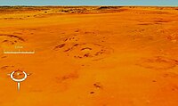
 Landsat image of the BP structure; screen capture from NASA World Wind Landsat image of the BP structure; screen capture from NASA World Wind | |
| Impact crater/structure | |
| Confidence | Confirmed |
| Diameter | 2 kilometres (1.2 mi) |
| Age | <120 Ma |
| Exposed | Yes |
| Drilled | No |
| Location | |
| Country | Libya |
 | |

The BP Structure, also known as Gebel Dalma, is an exposed impact crater in Libya. It is so called because it was identified by a BP (then British Petroleum) geological survey team.
French et al. state that the BP Structure and the larger Oasis crater, about 88 km (55 mi) to the south, were probably simultaneous impacts. Both impacts deform the Nubian Sandstone of early Cretaceous age.
See also
References
- "BP". Earth Impact Database. Planetary and Space Science Centre University of New Brunswick Fredericton. Retrieved 2009-08-12.
- BEVAN M. FRENCH, JAMES R. UNDERWOOD, EDWARD P. FISK; Shock-Metamorphic Features in Two Meteorite Impact Structures, Southeastern Libya. GSA Bulletin 1974;; 85 (9): 1425–1428. doi: https://doi.org/10.1130/0016-7606(1974)85<1425:SFITMI>2.0.CO;2
External links
- Anonymous (nd) Africa (Impact Craters), Earth Impact Database, Planetary and Space Science Centre, University of New Brunswick, New Brunswick, Canada.
25°19′10″N 24°18′34″E / 25.31944°N 24.30944°E / 25.31944; 24.30944
| BP | |
|---|---|
| Divisions | |
| Subsidiaries | |
| Brands | |
| Facilities | |
| Sponsorships | |
| People | |
| Controversies | |
| Historical units |
|
| Other | |
This geology article is a stub. You can help Misplaced Pages by expanding it. |
This Libya location article is a stub. You can help Misplaced Pages by expanding it. |

