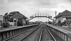
Belses is a village on the Ale Water, in the Scottish Borders area of Scotland the former Selkirkshire. It is situated close to Old Belses, and lies south of St Boswells, west of Jedburgh, north of Hawick, and east of Selkirk.
Other places nearby include Ancrum, Ashkirk, Belses, Hassendean, Lilliesleaf, Minto, Old Belses, and Salenside.

Belses was the site of a railway station on the former Waverley Line, a double track railway which linked Edinburgh with Carlisle. The NBR (North British Railway) closed in 1969.
See also
- Belses railway station (redirects to Waverley Line)
- List of places in the Scottish Borders
- List of places in Scotland
- List of closed railway stations in Britain
Sources
- Evans, D (1985) 'Practical Plans, Stow and Belses', Practical Model Railways, vol.June 1985, page(s):32-3
External links
- RCAHMS entry for Belses Station
- SCRAN: image of a North British Railway Stencil
- Robin Barbour collection: Images of Belses Station from the 1960s
- Geograph images of Belses station
- Waverley Route Heritage Association
55°31′00″N 2°41′03″W / 55.5168°N 2.6841°W / 55.5168; -2.6841
This Scottish Borders location article is a stub. You can help Misplaced Pages by expanding it. |