| Brimstone | |
|---|---|
| Hamlet | |
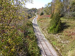
 Disused railway track in Forks of the Credit Provincial Park Disused railway track in Forks of the Credit Provincial Park | |
  | |
| Coordinates: 43°48′1″N 79°59′51″W / 43.80028°N 79.99750°W / 43.80028; -79.99750 | |
| Province | |
| Regional Municipality | Peel |
| Hamlet | Caledon |
| Elevation | 336 m (1,102 ft) |
| Population | |
| • Total | 53 |
Brimstone, also known locally as Brimstone Point, is a small hamlet located within the town of Caledon in the Peel Region of Ontario, Canada. The population was 53 people in the 2006 census.
Geography
Brimstone is located in the west side of Caledon. Moreover, it is located within Ward 1. Geographically, the hamlet is located eastly in close proximity to the village of Belfountain, north of Alton and south of Terra Cotta. The elevation is 336 meters above sea level.
Places of Interest
- Cox Property: Small zone, includes ruins of former castle and aerial tramway.
- Caledon Ski Club: Privately-owned ski hill and club.
- Forks of the Credit Provincial Park: Large protected park, located upon the Niagara Escarpment and the Credit River.
- Bruce Trail: Hiking and biking trail spanning 885 kilometers.
References
- "Wayback Machine" (PDF). Archived from the original (PDF) on 2012-02-23. Retrieved 2024-03-13.
- "Map of wards in Caledon". caledon.maps.arcgis.com. Retrieved 2024-03-13.
- "Google Street View Brimstone (Ontario) - Google Maps". street360.net. Retrieved 2024-03-13.
- MapCarta - Brimstone
- "OpenTopoMap - Topographische Karten aus OpenStreetMap". opentopomap.org. Retrieved 2024-03-13.
- hikingthegta (2015-10-25). "The Caledon Aerial Tramway – The Cox Property". Hiking the GTA. Retrieved 2024-03-13.
- "Caledon | Caledon Ski Club: Private Ski Club in Ontario". caledonskiclub.com. Retrieved 2024-03-30.
- "Welcome to Forks of the Credit Provincial Park". www.ontarioparks.ca. Retrieved 2024-03-13.
- "Bruce Trail Conservancy". 2021-11-30. Retrieved 2024-03-13.