| This article needs additional citations for verification. Please help improve this article by adding citations to reliable sources. Unsourced material may be challenged and removed. Find sources: "Brunnthaler Quellbach" – news · newspapers · books · scholar · JSTOR (October 2021) (Learn how and when to remove this message) |
48°08′53″N 11°36′01″E / 48.14806°N 11.60028°E / 48.14806; 11.60028
| Brunnthaler Quellbach | |
|---|---|
 Brunnthaler Quellbach Brunnthaler Quellbach | |
| Location | |
| Country | Germany |
| State | Bavaria |
| Physical characteristics | |
| Mouth | |
| • location | Isar |
| Basin features | |
| Progression | Isar→ Danube→ Black Sea |
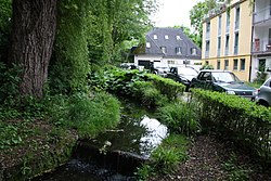
Brunnthaler Quellbach (also: Quellenbach) is a creek of Munich, Bavaria, Germany.
Until the end of the 19th century, the Munich river Brunnbach had its source near Bad Brunnthal in the lower Bogenhausen district and, as today, was a tributary of the Isar at St. Emmeran. At the time the Herzogpark was covered with buildings the Brunnbach was filled up north of the street Montgelaßstraße. The former upper course of the Brunnbach in the Maximiliansanlagen [de] park is now a river of its own and is called Brunnthaler Quellbach or Quellenbach.
The Brunnthaler Quellbach flows along the street Steinbacherstraße into the small pond Steinbacher Teich, from there a subterranean drainage south of the bridge Max-Joseph-Brücke [de] into the Isar exists.
See also
References
- westlich von Berglern strömende Wässer aufnimmt. Er entstand an der Kreuzung des Wekanales mit einer Mulde im Moosgelände, die nach den Erfahrungen der Hochwasser 1920 den Hauptzufluß bildete. Gleichzeitig münden in ihn Steinlacke und Hechtenbächl, während die normale Wassermenge der Sempt in eine besonderen Dücker unter dem Kanal durchgeführt wird. Der an den Semptflutdücker anschließende Semptflutkanal steht senkrecht zum Werkkanal und führt die Hochwässer (und bis 1930, d. i. bis Fertigstellung der gesamten Anlagen, auch das Betriebswasser) auf kürzestem Weg zur FIsar, die er nach 5,6 km bei der Mündung der Dorfen erreicht. ... Die Isarhanggewässer, die meist in den Auen versickerten, wurden teilweise in einen Graben (sog. Hangwassergraben) eingeleitet (zum mindesten das Überwasser) und durch Unterdückerung am Werkkanal der Isar zugeführt. Das gleiche geschah mit dem Mühl- oder Brunnbach bei Oberföhring. compare: Käthe Heindel, Die Umgestaltung der Isar durch den Menschen, 1937, S. 96
This article related to a river in Bavaria is a stub. You can help Misplaced Pages by expanding it. |