| Burakin Western Australia | |
|---|---|
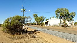
 Dowerin-Kalannie Road, Burakin, 2014 Dowerin-Kalannie Road, Burakin, 2014 | |
 | |
| Coordinates | 30°31′26″S 117°10′23″E / 30.524°S 117.173°E / -30.524; 117.173 |
| Population | 30 (SAL 2021) |
| Established | 1928 |
| Postcode(s) | 6467 |
| Elevation | 359 m (1,178 ft) |
| Area | 342.5 km (132.2 sq mi) |
| Location | |
| LGA(s) | Shire of Wongan-Ballidu |
| State electorate(s) | Moore |
| Federal division(s) | Durack |
Burakin is a small town near Kalannie in the eastern Wheatbelt region of Western Australia.
The townsite was gazetted in 1928. The name is an Aboriginal word of unknown meaning, and was suggested by the Wongan Hills Road Board in 1927. The original spelling was to have been Borrikin.
Railways
Burakin is the junction for the Amery to Kalannie railway line and the branch railway line to Bonnie Rock. The line was completed on 27 April 1931. Despite aspirations for the railway in the 1930s. services between Beacon and Bonnie Rock were under threat of suspension in 1953, and closed in the same year.
Earthquakes
In 2000 and 2001 Burakin was the epicentre of a series of earthquakes, now known as the Burakin Swarm – a significant series of seismographic events that are considered important in understanding the South West Seismic Zone.
References
- Australian Bureau of Statistics (28 June 2022). "Burakin (suburb and locality)". Australian Census 2021 QuickStats. Retrieved 28 June 2022.

- Western Australia. Department of Lands and Surveys (1929), Townsite of Burakin, Ninghan District, Dept. of Lands & Surveys W.A, retrieved 21 August 2022
- "History of country town names – B". Western Australian Land Information Authority. Archived from the original on 14 March 2022. Retrieved 8 June 2007.
- Rails through the Wodjil Milne, Rod Australian Railway Historical Society Bulletin, January, 1999 pp3-9
- "BURAKIN". The Dowerin Guardian and Amery Line Advocate. Vol. 3, no. 16. Western Australia. 5 April 1930. p. 3. Retrieved 27 August 2024 – via National Library of Australia.
- "Burakin -- Bonnie Rock Railway". The Farmers' Weekly. Vol. 7, no. 320. Western Australia. 24 September 1953. p. 15. Retrieved 27 August 2024 – via National Library of Australia.
- "Minister Investigation Burakin-Bonnie Rock Railway". The Dowerin Guardian and Amery Line Advocate. Vol. XXIV, no. 12. Western Australia. 15 October 1953. p. 1. Retrieved 27 August 2024 – via National Library of Australia.
- "BURAKIN-BONNIE ROCK". The Farmers' Weekly. Vol. 7, no. 327. Western Australia. 12 November 1953. p. 3. Retrieved 27 August 2024 – via National Library of Australia.
- "Third quake in six months hits Burakin.(Local)", The Australian (National, Australia), News Limited: 004, 6 March 2002, retrieved 27 August 2024
- "Researchers surf seismic wave.(Features)", The Australian (National, Australia), News Limited: 032, 10 April 2002, retrieved 27 August 2024
- "Quakeville builds to something big.(Local)", The Australian (National, Australia), News Limited: 001, 2 April 2002, retrieved 27 August 2024
- "UWA Seismic Events in WA – Burakin Swarm". 2005. Archived from the original on 11 July 2008. Retrieved 20 April 2011.
- Australia. Department of Industry, Tourism and Resources (30 June 2002), "Geoscience Australia (30 June 2002)", Annual Report (539 of 2002), Department of Industry, Tourism and Resources: 199, ISSN 1443-8267
- "Shaking spot quakes way to seismic record", Australasian Business Intelligence, COMTEX News Network, Inc: 1008364i9825, 30 December 2001, ISSN 1320-6680
External links
![]() Media related to Burakin, Western Australia at Wikimedia Commons
Media related to Burakin, Western Australia at Wikimedia Commons