| Candarave | |
|---|---|
| Province | |
 Flag Flag Coat of arms Coat of arms | |
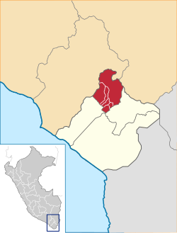
 Location of Candarave in the Tacna Region Location of Candarave in the Tacna Region | |
| Country | Peru |
| Region | Tacna |
| Founded | 1821 |
| Capital | Candarave |
| Government | |
| • Mayor | Mario Genaro Copa Conde (2007-2010) |
| Area | |
| • Total | 2,261.10 km (873.02 sq mi) |
| Elevation | 3,415 m (11,204 ft) |
| Population | |
| • Total | 8,543 |
| • Density | 3.8/km (9.8/sq mi) |
| UBIGEO | 2302 |
| Website | www.municandarave.gob.pe |
Candarave is the smallest of the four provinces in the Tacna Region in southern Peru. Its capital is Candarave.
Boundaries
- North: Mariscal Nieto Province in the Moquegua Region
- East: El Collao Province in the Puno Region
- Southeast: Tarata Province
- Southwest: Jorge Basadre Province
Geography
Some of the highest peaks of the province are Tutupaka and Yukamani, both are active volcanoes. Other mountains are listed below:
- Apachita Limani
- Arichuwa
- Chinchillani
- Chuqi Ananta
- Churi Laq'a
- Churi Wiqu
- Ch'alla Q'awa
- Ch'alluma
- Ch'ankha Qullu
- Ch'ankhani
- Ch'iyar Jaqhi
- Iru Uma
- Jichu Qullu
- Jisk'a Larqanku
- Kuntur Ikiña
- K'ank'awi
- K'ara K'ara
- Larqanku
- Nasa Parqu
- Panti Usu
- Paxsi Awki
- Phaq'u Muqu
- Phaq'u Q'awa
- Pharaquta
- Qina Mich'i
- Qupa Phuju
- Qura Jawi
- Salla Jaqhi
- Sasawini
- Taypi Sirka
- Titini
- Tutupaka (Moquegua-Tacna)
- Wañuma
- Warintapani
- Watañani
- Waytiri
- Wila Qullu
- Wila Wilani
- Wisk'acha
- Yunkani
Political division
The province is divided into six districts (Spanish: distritos, singular: distrito), each of which is headed by a mayor (alcalde):
Ethnic groups
The province is inhabited by indigenous citizens of Aymara descent. Spanish, however, is the language which the majority of the population (78.17%) learnt to speak in childhood, 20.94% of the residents started speaking using the Aymara language (2007 Peru Census).
See also
References
- escale.minedu.gob.pe - UGEL map of the province of Candarave (Tacna Region)
- inei.gob.pe Archived January 27, 2013, at the Wayback Machine INEI, Peru, Censos Nacionales 2007
| |
|---|---|
17°16′13″S 70°15′06″W / 17.270150°S 70.251625°W / -17.270150; -70.251625
This Tacna Region geography article is a stub. You can help Misplaced Pages by expanding it. |