Misplaced Pages

Zhag'yab County

Article snapshot taken from Wikipedia with creative commons attribution-sharealike license. Give it a read and then ask your questions in the chat. We can research this topic together.
(Redirected from Chaya County) County in Tibet, China
Zhag'yab County 察雅县 • བྲག་གཡབ་རྫོང་།
County
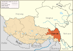
Location of Zhag'yab County within TibetLocation of Zhag'yab County within Tibet
Zhag'yab County is located in TibetZhag'yab CountyZhag'yab CountyLocation in TibetShow map of TibetZhag'yab County is located in ChinaZhag'yab CountyZhag'yab CountyZhag'yab County (China)Show map of China
Coordinates: 30°39′22″N 97°34′01″E / 30.656°N 97.567°E / 30.656; 97.567
CountryChina
Autonomous regionTibet
Prefecture-level cityChamdo
County seatYêndum
Area
 • Total8,255.59 km (3,187.50 sq mi)
Population
 • Total57,065
 • Density6.9/km (18/sq mi)
Time zoneUTC+8 (China Standard)
Websitechaya.changdu.gov.cn
Zhag'yab County
Chinese name
Simplified Chinese察雅县
Traditional Chinese察雅縣
Transcriptions
Standard Mandarin
Hanyu PinyinCháyǎ Xiàn
Tibetan name
Tibetanབྲག་གཡབ་རྫོང་།
Transcriptions
Wyliebrag g.yab rdzong
Tibetan PinyinZhag'yab Zong

Zhag'yab County (Tibetan: བྲག་གཡབ་རྫོང, Wylie: brag g.yab rdzong, THL: drak yap dzong་; Chinese: 察雅县; pinyin: Chá yǎ xiàn), also spelled Dragyab, Chagyab, Draya, and Chaya, is a county of the Chamdo Prefecture in the Tibet Autonomous Region, China.

Administrative divisions

Zhag'yab County is divided in 3 towns and 10 townships.

Name Chinese Hanyu Pinyin Tibetan Wylie
Towns
Yêndum Town 烟多镇 Yānduō zhèn དབྱེན་འདུམ་གྲོང་རྡལ། dbyen 'dum grong rdal
Jamdün Town 香堆镇 Xiāngduī zhèn བྱངས་མདུན་གྲོང་རྡལ། byangs mdun grong rdal
Gyithang Town 吉塘镇 Jítáng zhèn དཀྱིལ་ཐང་གྲོང་རྡལ། dkyil thang grong rdal
Townships
Zangsar Township 宗沙乡 Zōngshā xiāng གཙང་གསར་ཤང་། gtsang gsar shang
Kargong Township 卡贡乡 Kǎgòng xiāng མཁར་སྒང་ཤང་། mkhar sgang shang
Rangzhub Township 荣周乡 Róngzhōu xiāng རང་གྲུང་ཤང་། rang grung shang
Pelri Township 巴日乡 Bārì xiāng དཔལ་རི་ཤང་། dpal ri shang
Acur Township 阿孜乡 Ãzī xiāng ཝ་མཁར་ཤང་། a tshur shang
Wakhar Township 王卡乡 Wángkǎ xiāng ཨ་ཚུར་ཤང་། wa mkhar shang
Shingka Township 新卡乡 Xīnkǎ xiāng ཤིང་དཀའ་ཤང་། shin dka' shang
Khentang Township 肯通乡 Kěntōng xiāng འཁན་ཐང་ཤང་། 'khan thang shang
Korra Township 扩达乡 Kuòdá xiāng འཁོར་རྭ་ཤང་། 'khor rwa shang
Cala Township
(Calamdo)
察拉乡 Chálā xiāng ཚྭ་ལ་ཤང་། tswa la shang

References

  1. "昌都市第七次全国人口普查主要数据公报" (in Chinese). Government of Chamdo. 2021-06-22.
  2. ^ Tibet 2002: A Year Book, Tibet Information Network, London, p. 145.
  3. Mehra, Parshotam (1974). The McMahon Line and After: A Study of the Triangular Contest on India's North-eastern Frontier Between Britain, China and Tibet, 1904-47. Macmillan. pp. 67–68. ISBN 9780333157374 – via archive.org.
County-level divisions of Tibet Autonomous Region
Lhasa (capital)
Prefecture-level
cities
Lhasa
Xigazê
Qamdo
Nyingchi
Shannan
Nagqu
Prefecture
Ngari
** Southern portions of these counties are claimed by the People's Republic of China as part of the South Tibet area, but are administered by India.
Chamdo
County-level
divisions
DistrictKaruo
Counties
Location of Chamdo Prefecture in the Tibet Autonomous Region
Settlements
Sciences
Cultures


Stub icon

This Chamdo, Tibet location article is a stub. You can help Misplaced Pages by expanding it.

Categories: