| Range Regional Airport | |||||||||||||||
|---|---|---|---|---|---|---|---|---|---|---|---|---|---|---|---|
 | |||||||||||||||
| Summary | |||||||||||||||
| Airport type | Public | ||||||||||||||
| Owner | Chisholm-Hibbing Airport | ||||||||||||||
| Serves | Hibbing, Minnesota | ||||||||||||||
| Elevation AMSL | 1,354 ft / 413 m | ||||||||||||||
| Coordinates | 47°23′12″N 092°50′20″W / 47.38667°N 92.83889°W / 47.38667; -92.83889 | ||||||||||||||
| Website | RangeRegionalAirport.com | ||||||||||||||
| Maps | |||||||||||||||
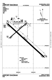
 FAA airport diagram | |||||||||||||||
  | |||||||||||||||
| Runways | |||||||||||||||
| |||||||||||||||
| Statistics (2022) | |||||||||||||||
| |||||||||||||||
| Source: Federal Aviation Administration | |||||||||||||||
Range Regional Airport (IATA: HIB, ICAO: KHIB, FAA LID: HIB) is a public use airport located four nautical miles (5 mi, 7 km) southeast of the central business district of Hibbing, in Saint Louis County, Minnesota, United States. It was formerly known as Chisholm-Hibbing Airport or Chisholm-Hibbing Municipal Airport. The airport is mostly used for general aviation but is also served by one commercial and one charter airline. Scheduled passenger service is subsidized by the Essential Air Service program.
As per Federal Aviation Administration records, the airport had 8,896 passenger boardings (enplanements) in calendar year 2008, 8,926 enplanements in 2009, and 11,227 in 2010. It is included in the National Plan of Integrated Airport Systems for 2011–2015, which categorized it as a non-primary commercial service airport based on 2008 enplanements (between 2,500 and 10,000), but would be considered primary commercial service based on enplanements in 2010.
Facilities and aircraft
Range Regional Airport covers an area of 1,600 acres (647 ha) at an elevation of 1,354 feet (413 m) above mean sea level. It has two runways with asphalt surfaces: 13/31 is 6,758 by 150 feet (2,060 x 46 m) and 4/22 is 3,075 by 75 feet (937 x 23 m).
For the 12-month period ending December 31, 2022, the airport had 28,850 aircraft operations, an average of 79 per day: 84% general aviation, 8% air taxi, 9% scheduled commercial and <1% military. At that time, there were 42 aircraft based at this airport: 40 single-engine, 1 multi-engine and 1 helicopter.
Airline and destination
Passenger
| Airlines | Destinations |
|---|---|
| Delta Connection | Minneapolis/St. Paul |
| Destination map |
|---|
 |
Top destinations
| Rank | City | Passengers | Carriers |
|---|---|---|---|
| 1 | Minneapolis/St. Paul | 11,000 | Delta Connection |
Accidents and incidents
2 January 1993: An Express Airlines Saab 340A crashed hard onto the runway at Chisholm-Hibbing Municipal Airport due to wing ice accretion. There were no fatalities, but the aircraft was destroyed.
1 December 1993: Northwest Airlink Flight 5719 crashed while on approach to Chisholm-Hibbing Airport. All 18 passengers and crew on board were killed.
See also
References
- ^ FAA Airport Form 5010 for HIB PDF. Federal Aviation Administration. Effective September 7, 2023.
- "Enplanements for CY 2008" (PDF, 1.0 MB). CY 2008 Passenger Boarding and All-Cargo Data. Federal Aviation Administration. December 18, 2009.
- "Enplanements for CY 2010" (PDF, 189 KB). CY 2010 Passenger Boarding and All-Cargo Data. Federal Aviation Administration. October 4, 2011.
- "2011–2015 NPIAS Report, Appendix A" (PDF, 2.03 MB). National Plan of Integrated Airport Systems. Federal Aviation Administration. October 4, 2010.
- "Delta Air Lines route map - North America from Minneapolis-St.Paul". www.airlineroutemaps.com. Retrieved 2022-06-11.
- "Hibbing, MN: Range Regional (HIB)". Bureau of Transportation Statistics. December 2020. Retrieved November 16, 2024.
- Accident description for N342PX at the Aviation Safety Network. Retrieved on September 28, 2023.
- "18 Killed in Commuter Plane Crash in Minn". Chicago Sun-Times. December 2, 1993. Archived from the original on November 4, 2012. Retrieved July 3, 2010.
External links
- Range Regional Airport, official website
- Range Regional Airport at City of Hibbing website
- "Range Regional Airport (HIB)" (PDF). Archived from the original (PDF) on 2006-10-27. at Minnesota DOT Airport Directory
- Aerial image as of May 1992 from USGS The National Map
- FAA Terminal Procedures for HIB, effective December 26, 2024
- Resources for this airport:
- FAA airport information for HIB
- AirNav airport information for KHIB
- ASN accident history for HIB
- FlightAware airport information and live flight tracker
- NOAA/NWS weather observations: current, past three days
- SkyVector aeronautical chart, Terminal Procedures