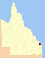
Cadastral in Queensland, Australia
| Cook Queensland | |||||||||||||||
|---|---|---|---|---|---|---|---|---|---|---|---|---|---|---|---|
 Location within Queensland Location within Queensland | |||||||||||||||
| |||||||||||||||
Download coordinates as:
The county of Cook is a cadastral division of Queensland, centred on the city of Bundaberg, and its name honours Captain James Cook. It was officially named and bounded by the Governor in Council on 7 March 1901 under the Land Act 1897.
Parishes
Cook is divided into parishes, as listed below:
See also
References
- Wide Bay/Burnett District, County of Cook Maps - D3 Series at Queensland Archives.
- "Cook (entry 8035)". Queensland Place Names. Queensland Government. Retrieved 8 September 2015.
External links
- "Map of the County of Cook". Queensland Government. 1902.
- "Map of the County of Cook". Queensland Government. 1920.
24°52′S 152°21′E / 24.867°S 152.350°E / -24.867; 152.350
Category: