| Cuddy Canyon | |
|---|---|
| Canyon | |
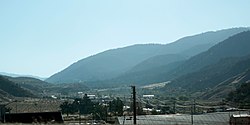
 The canyon, viewed from Interstate 5 to the east; part of Lebec can be seen along Frazier Mountain Park Road The canyon, viewed from Interstate 5 to the east; part of Lebec can be seen along Frazier Mountain Park Road | |
 | |
| Coordinates: 34°49′05″N 118°53′05″W / 34.81806°N 118.88472°W / 34.81806; -118.88472 | |
| Location | Kern County and Ventura County |
| Range | Transverse Ranges |
Cuddy Canyon is a canyon running along the boundary line between Kern County and Ventura County, California. It lies inside the Los Padres National Forest and southern San Emigdio Mountains.
The canyon includes the Tejon Pass mountain communities of Frazier Park, and Lake of the Woods. For purposes of the census-designated places only, none of the sparsely populated Cuddy Valley that lies within Ventura County are included for the statistics for Frazier Park or Lake of the Woods.
History
The 18th-19th century El Camino Viejo passed through the valley canyon, between the Los Angeles Basin and San Francisco Bay Area missions and settlements. Cuddy Canyon was named for John Fletcher Cuddy who settled and ranched in the canyon and in Cuddy Valley.
See also
References
- U.S. Geological Survey Geographic Names Information System: Cuddy Canyon
- "Boundary Map and Geodata for the CDP of Frazier Park in California, U.S.A." Archived 2014-09-14 at the Wayback Machine. MapTechnica.com. Retrieved September 13, 2014
- "Boundary Map and Geodata for the CDP of Lake of the Woods in California, U.S.A." Archived 2014-09-14 at the Wayback Machine. MapTechnica.com. Retrieved September 13, 2014
This Kern County, California-related article is a stub. You can help Misplaced Pages by expanding it. |
This Ventura County, California–related article is a stub. You can help Misplaced Pages by expanding it. |