| This article needs additional citations for verification. Please help improve this article by adding citations to reliable sources. Unsourced material may be challenged and removed. Find sources: "Via dei Tribunali, Naples" – news · newspapers · books · scholar · JSTOR (October 2024) (Learn how and when to remove this message) |


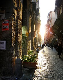
Via dei Tribunali is a street in the old historic center of Naples, Italy.
It was the main decumanus or Decumano Maggiore — that is, the main east-west street — of the ancient Greek and then Roman city of Neapolis, paralleled to the south by the lower decumanus (Decumano Inferiore, now called Spaccanapoli) and to the north by the upper decumanus (Decumano Superiore) (now via Anticaglia and Via della Sapienza). The three decumani were (and still are) intersected by numerous north-south cross-streets called cardini, together forming the grid of the ancient city. The modern streets/alleys overlie and follow the ancient grid of these ancient streets.
The length of the modern Via dei Tribunali was determined by the urban expansion requirements of the Spanish starting in the early 16th century. The street runs from the church of San Pietro a Maiella and adjacent Naples Music Conservatory at the west end of the old city for about three-quarters of a mile, passing the central cross-road at via San Gregorio Armeno, then crossing via Duomo near the Cathedral of Naples and ending at what was, until quite recently, the main Naples courthouse (Italian: Tribunale), from which the street draws its name.
Buildings and Structures
The following are important or ancient buildings along the Street from East to West:
- Church of Santa Maria della Mercede e Sant'Alfonso Maria de' Liguori
- Sant'Antonio delle Monache a Port'Alba
- Conservatory of San Pietro a Majella
- Church of San Pietro a Majella
- Church of Croce di Lucca
- Pontano Chapel
- Church of Santa Maria Maggiore alla Pietrasanta
- Palazzo Spinelli di Laurino
- Palazzo Filippo d'Angiò
- Basilica Church of San Paolo Maggiore
- Basilica Church of San Lorenzo Maggiore
- Church of Santa Maria delle Anime del Purgatorio ad Arco
- Church of Girolamini
- Church of Santa Maria della Colonna
- Duomo di Napoli (at corner of via Duomo)
- Guglia di San Gennaro
- Palazzo Caracciolo di Gioiosa
- Pio Monte della Misericordia
- Church of Santa Maria della Pace
- Church of Santa Maria del Rifugio
- Church of San Tommaso a Capuana
- Chapel of the Monte dei Poveri
- Castel Capuano
- Guglia di San Gaetano
References
- Holleran, Claire (October 2017). "Finding commerce: the taberna and the identification of Roman commercial space". Papers of the British School at Rome. 85: 151. doi:10.1017/S0068246217000010. hdl:10871/26092. ISSN 0068-2462. Retrieved 3 October 2024.
- Martucci, Caterina Serena; Toniolo, Luana (2011). "Ceramica da fuoco tardo-antica in area vesuviana: dinamiche di scambio tra costa ed entroterra". Rivista di Studi Pompeiani. 22: 75. ISSN 1120-3579. Retrieved 3 October 2024.
40°50′N 14°15′E / 40.833°N 14.250°E / 40.833; 14.250
This Italian road or road transport-related article is a stub. You can help Misplaced Pages by expanding it. |