 Size of this preview: 662 × 599 pixels. Other resolutions: 265 × 240 pixels | 530 × 480 pixels | 849 × 768 pixels | 1,131 × 1,024 pixels | 2,454 × 2,221 pixels.
Original file (2,454 × 2,221 pixels, file size: 1.13 MB, MIME type: image/jpeg)
| This is a file from the Wikimedia Commons. Information from its description page there is shown below. Commons is a freely licensed media file repository. You can help. |
Summary
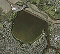
| DescriptionŌrākei Basin aerial view 2017.jpg | English: Ōrākei Basin full of water during low tide. Exposed mud flats can be seen in Hobson bay to the northwest, and along the tidal Purewa Stream at the north. The railway causeway clearly delineates the basin from the stream. The location of the water control gates can be seen at the eastern extent of the basin. |
| Date | |
| Source | Sourced from the LINZ Data Service (Auckland 0.075m Urban Aerial Photos (2017) https://data.linz.govt.nz/layer/95497) and licensed by Auckland Council for re-use under the Creative Commons Attribution 4.0 International. |
| Author | Auckland Council |
| Camera location | 36° 51′ 58.72″ S, 174° 48′ 47.63″ E | View this and other nearby images on: OpenStreetMap |
|---|
Licensing
- You are free:
- to share – to copy, distribute and transmit the work
- to remix – to adapt the work
- Under the following conditions:
- attribution – You must give appropriate credit, provide a link to the license, and indicate if changes were made. You may do so in any reasonable manner, but not in any way that suggests the licensor endorses you or your use.
Captions
Aerial image of Ōrākei Basin, Auckland, New Zealand.Items portrayed in this file
depicts
Ōrākei Basin
Orakei railway station
Meadowbank railway station
copyright status<\/a>"}},"text\/plain":{"en":{"":"copyright status"}}},"{\"value\":{\"entity-type\":\"item\",\"numeric-id\":50423863,\"id\":\"Q50423863\"},\"type\":\"wikibase-entityid\"}":{"text\/html":{"en":{"P6216":"copyrighted<\/a>"}},"text\/plain":{"en":{"P6216":"copyrighted"}}}}">copyright status
copyrighted
copyright license<\/a>"}},"text\/plain":{"en":{"":"copyright license"}}},"{\"value\":{\"entity-type\":\"item\",\"numeric-id\":20007257,\"id\":\"Q20007257\"},\"type\":\"wikibase-entityid\"}":{"text\/html":{"en":{"P275":"Creative Commons Attribution 4.0 International<\/a>"}},"text\/plain":{"en":{"P275":"Creative Commons Attribution 4.0 International"}}}}">copyright license
Creative Commons Attribution 4.0 International
coordinates of the point of view<\/a>"}},"text\/plain":{"en":{"":"coordinates of the point of view"}}},"{\"value\":{\"latitude\":-36.866312,\"longitude\":174.81323,\"altitude\":null,\"precision\":1.0e-6,\"globe\":\"http:\\\/\\\/www.wikidata.org\\\/entity\\\/Q2\"},\"type\":\"globecoordinate\"}":{"text\/html":{"en":{"P1259":"36\u00b051'58.723"S, 174\u00b048'47.628"E"}},"text\/plain":{"en":{"P1259":"36\u00b051'58.723\"S, 174\u00b048'47.628\"E"}}}}">coordinates of the point of view
36°51'58.723"S, 174°48'47.628"E
inception<\/a>"}},"text\/plain":{"en":{"":"inception"}}},"{\"value\":{\"time\":\"+2017-01-01T00:00:00Z\",\"timezone\":0,\"before\":0,\"after\":0,\"precision\":9,\"calendarmodel\":\"http:\\\/\\\/www.wikidata.org\\\/entity\\\/Q1985727\"},\"type\":\"time\"}":{"text\/html":{"en":{"P571":"2017"}},"text\/plain":{"en":{"P571":"2017"}}}}">inception
2017
media type<\/a>"}},"text\/plain":{"en":{"":"media type"}}},"{\"value\":\"image\\\/jpeg\",\"type\":\"string\"}":{"text\/html":{"en":{"P1163":"image\/jpeg"}},"text\/plain":{"en":{"P1163":"image\/jpeg"}}}}">media type
image/jpeg
data size<\/a>"}},"text\/plain":{"en":{"":"data size"}}},"{\"value\":{\"amount\":\"+1185784\",\"unit\":\"http:\\\/\\\/www.wikidata.org\\\/entity\\\/Q8799\"},\"type\":\"quantity\"}":{"text\/html":{"en":{"P3575":"1,185,784 byte<\/span>"}},"text\/plain":{"en":{"P3575":"1,185,784 byte"}}}}">data size
1,185,784 byte
height<\/a>"}},"text\/plain":{"en":{"":"height"}}},"{\"value\":{\"amount\":\"+2221\",\"unit\":\"http:\\\/\\\/www.wikidata.org\\\/entity\\\/Q355198\"},\"type\":\"quantity\"}":{"text\/html":{"en":{"P2048":"2,221 pixel<\/span>"}},"text\/plain":{"en":{"P2048":"2,221 pixel"}}}}">height
2,221 pixel
width<\/a>"}},"text\/plain":{"en":{"":"width"}}},"{\"value\":{\"amount\":\"+2454\",\"unit\":\"http:\\\/\\\/www.wikidata.org\\\/entity\\\/Q355198\"},\"type\":\"quantity\"}":{"text\/html":{"en":{"P2049":"2,454 pixel<\/span>"}},"text\/plain":{"en":{"P2049":"2,454 pixel"}}}}">width
2,454 pixel
checksum<\/a>"}},"text\/plain":{"en":{"":"checksum"}}},"{\"value\":\"8adfd092d022999cbf33863f31b8765b1d6a08bd\",\"type\":\"string\"}":{"text\/html":{"en":{"P4092":"8adfd092d022999cbf33863f31b8765b1d6a08bd"}},"text\/plain":{"en":{"P4092":"8adfd092d022999cbf33863f31b8765b1d6a08bd"}}},"{\"value\":{\"entity-type\":\"property\",\"numeric-id\":459,\"id\":\"P459\"},\"type\":\"wikibase-entityid\"}":{"text\/html":{"en":{"":"determination method or standard<\/a>"}},"text\/plain":{"en":{"":"determination method or standard"}}},"{\"value\":{\"entity-type\":\"item\",\"numeric-id\":13414952,\"id\":\"Q13414952\"},\"type\":\"wikibase-entityid\"}":{"text\/html":{"en":{"P459":"SHA-1<\/a>"}},"text\/plain":{"en":{"P459":"SHA-1"}}}}">checksum
8adfd092d022999cbf33863f31b8765b1d6a08bd
determination method or standard: SHA-1File history
Click on a date/time to view the file as it appeared at that time.
| Date/Time | Thumbnail | Dimensions | User | Comment | |
|---|---|---|---|---|---|
| current | 23:10, 23 December 2022 |  | 2,454 × 2,221 (1.13 MB) | RadishSlice | Add higher resolution export, same source and extent. |
| 22:53, 23 December 2022 |  | 589 × 533 (79 KB) | RadishSlice | Uploaded a work by Auckland Council from Sourced from the LINZ Data Service (Auckland 0.075m Urban Aerial Photos (2017) https://data.linz.govt.nz/layer/95497) and licensed by Auckland Council for re-use under the Creative Commons Attribution 4.0 International. with UploadWizard |
File usage
The following page uses this file: