 Size of this preview: 306 × 599 pixels. Other resolutions: 122 × 240 pixels | 245 × 480 pixels | 392 × 768 pixels | 523 × 1,024 pixels | 1,967 × 3,853 pixels.
Original file (1,967 × 3,853 pixels, file size: 942 KB, MIME type: image/png)
| This is a file from the Wikimedia Commons. Information from its description page there is shown below. Commons is a freely licensed media file repository. You can help. |
Summary
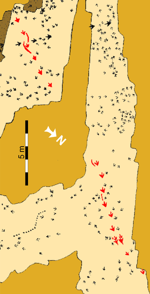
| Description“Top Surface” tracksite (SGDS.18).png |
Schematic map of the “Top Surface” tracksite (SGDS.18). Beige shaded areas represent the “Top Surface” of the Main Track-bearing Sandstone Bed; gold shaded areas are unexcavated; brown areas represent areas removed after mapping to examine lower horizons. The Eubrontes trackway that includes the crouching trace is highlighted in red. |
||
| Date | |||
| Source | http://journals.plos.org/plosone/article?id=10.1371/journal.pone.0004591 | ||
| Author | Andrew R. C. Milner, Jerald D. Harris, Martin G. Lockley, James I. Kirkland, Neffra A. Matthews | ||
| Permission (Reusing this file) |
|
Captions
Add a one-line explanation of what this file representsItems portrayed in this file
depicts
copyright status<\/a>"}},"text\/plain":{"en":{"":"copyright status"}}},"{\"value\":{\"entity-type\":\"item\",\"numeric-id\":50423863,\"id\":\"Q50423863\"},\"type\":\"wikibase-entityid\"}":{"text\/html":{"en":{"P6216":"copyrighted<\/a>"}},"text\/plain":{"en":{"P6216":"copyrighted"}}}}">copyright status
copyrighted
copyright license<\/a>"}},"text\/plain":{"en":{"":"copyright license"}}},"{\"value\":{\"entity-type\":\"item\",\"numeric-id\":18810333,\"id\":\"Q18810333\"},\"type\":\"wikibase-entityid\"}":{"text\/html":{"en":{"P275":"Creative Commons Attribution 2.5 Generic<\/a>"}},"text\/plain":{"en":{"P275":"Creative Commons Attribution 2.5 Generic"}}}}">copyright license
Creative Commons Attribution 2.5 Generic
inception<\/a>"}},"text\/plain":{"en":{"":"inception"}}},"{\"value\":{\"time\":\"+2009-01-01T00:00:00Z\",\"timezone\":0,\"before\":0,\"after\":0,\"precision\":9,\"calendarmodel\":\"http:\\\/\\\/www.wikidata.org\\\/entity\\\/Q1985727\"},\"type\":\"time\"}":{"text\/html":{"en":{"P571":"2009"}},"text\/plain":{"en":{"P571":"2009"}}}}">inception
2009
media type<\/a>"}},"text\/plain":{"en":{"":"media type"}}},"{\"value\":\"image\\\/png\",\"type\":\"string\"}":{"text\/html":{"en":{"P1163":"image\/png"}},"text\/plain":{"en":{"P1163":"image\/png"}}}}">media type
image/png
File history
Click on a date/time to view the file as it appeared at that time.
| Date/Time | Thumbnail | Dimensions | User | Comment | |
|---|---|---|---|---|---|
| current | 05:12, 8 November 2020 |  | 1,967 × 3,853 (942 KB) | FunkMonk | Turned as in source. |
| 04:36, 18 June 2019 |  | 3,853 × 1,967 (847 KB) | FunkMonk | {{Information |Description=Schematic map of the “Top Surface” tracksite (SGDS.18). Beige shaded areas represent the “Top Surface” of the Main Track-bearing Sandstone Bed; gold shaded areas are unexcavated; brown areas represent areas removed after mapping to examine lower horizons. The Eubrontes trackway that includes the crouching trace is highlighted in red. |Source=http://journals.plos.org/plosone/article?id=10.1371/journal.pone.0004591 |Date=2009 |Author=Andrew R. C. Milner, Jerald D. Ha... |
File usage
The following 2 pages use this file:
Global file usage
The following other wikis use this file:
- Usage on zh.wikipedia.org
Metadata
This file contains additional information, probably added from the digital camera or scanner used to create or digitize it.
If the file has been modified from its original state, some details may not fully reflect the modified file.
| Horizontal resolution | 93 dpc |
|---|---|
| Vertical resolution | 93 dpc |
