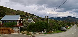
Town in Nelson, New Zealand
| Glenduan | |
|---|---|
| Town | |
 Glenduan Glenduan | |
| Coordinates: 41°11′10″S 173°21′50″E / 41.18611°S 173.36389°E / -41.18611; 173.36389 | |
| Country | New Zealand |
| Region | Nelson |
| Ward |
|
| Electorates | |
| Government | |
| • Territorial Authority | Nelson City Council |
| • Mayor of Nelson | Nick Smith |
| • Nelson MP | Rachel Boyack |
| • Te Tai Tonga MP | Tākuta Ferris |
| Area | |
| • Total | 0.13 km (0.05 sq mi) |
| Population | |
| • Total | 189 |
| • Density | 1,500/km (3,800/sq mi) |
Glenduan is a small township lying to the north of Nelson, New Zealand. It lies on the shore of Tasman Bay / Te Tai-o-Aorere between the northern end of Boulder Bank and Pepin Island.
The settlement's main park, Glenduan Reserve, is a public beach and local park.
Horoirangi Marine Reserve is located offshore of Glenduan.
Demographics
Glenduan is in an SA1 statistical area which covers 0.13 km (0.050 sq mi). It is part of the Nelson Rural statistical area.
| Year | Pop. | ±% p.a. |
|---|---|---|
| 2006 | 222 | — |
| 2013 | 180 | −2.95% |
| 2018 | 189 | +0.98% |
| Source: | ||
Glenduan had a population of 189 at the 2018 New Zealand census, an increase of 9 people (5.0%) since the 2013 census, and a decrease of 33 people (−14.9%) since the 2006 census. There were 75 households, comprising 90 males and 96 females, giving a sex ratio of 0.94 males per female. The median age was 43.4 years (compared with 37.4 years nationally), with 39 people (20.6%) aged under 15 years, 21 (11.1%) aged 15 to 29, 102 (54.0%) aged 30 to 64, and 27 (14.3%) aged 65 or older.
Ethnicities were 98.4% European/Pākehā, 4.8% Māori, 1.6% Pasifika, and 4.8% other ethnicities. People may identify with more than one ethnicity.
Although some people chose not to answer the census's question about religious affiliation, 63.5% had no religion, 20.6% were Christian, 3.2% were Hindu, 1.6% were Buddhist and 1.6% had other religions.
Of those at least 15 years old, 60 (40.0%) people had a bachelor's or higher degree, and 12 (8.0%) people had no formal qualifications. The median income was $35,100, compared with $31,800 nationally. 30 people (20.0%) earned over $70,000 compared to 17.2% nationally. The employment status of those at least 15 was that 69 (46.0%) people were employed full-time, 39 (26.0%) were part-time, and 3 (2.0%) were unemployed.
References
- ^ "ArcGIS Web Application". statsnz.maps.arcgis.com. Retrieved 15 July 2023.
- ^ "Statistical area 1 dataset for 2018 Census". Statistics New Zealand. March 2020. 7022879.
- Reed New Zealand atlas (2004) Auckland: Reed Publishing. Map 59. ISBN 0 7900 0952 8
- Wise's Nelson-Blenheim "Easyread" Map ISBN 1 877402 50 8
- "Nelson Parks and Reserves". gdc.govt.nz. Gisborne District Council.
- "DOC Places to Go - Nelson-Tasman". doc.govt.nz. Department of Conservation.
- 2018 Census place summary: Nelson Rural
| Nelson, New Zealand | |||||||||
|---|---|---|---|---|---|---|---|---|---|
| Suburbs |
| ||||||||
| Geographic features | |||||||||
| Facilities and attractions |
| ||||||||
| Government | |||||||||
| Organisations | |||||||||
| Schools | |||||||||
| Media | |||||||||
| Iwi | |||||||||