Misplaced Pages

Grade I and II* listed buildings in the London Borough of Croydon

Article snapshot taken from Wikipedia with creative commons attribution-sharealike license. Give it a read and then ask your questions in the chat. We can research this topic together.
(Redirected from Grade I and II* listed buildings in Croydon)

Map all coordinates using OpenStreetMap

Download coordinates as:

There are over 9,000 Grade I listed buildings and 20,000 Grade II* listed buildings in England. This page is a list of these buildings in the London Borough of Croydon.

Grade I

Name Location Type Completed Date designated Grid ref.
Geo-coordinates
Entry number Image
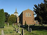
Church of All Saints Sanderstead Church Late 13th century 20 May 1954 TQ3413861485
51°20′12″N 0°04′33″W / 51.33664°N 0.07577°W / 51.33664; -0.07577 (Church of All Saints)
1079341
Church of All Saints
More images
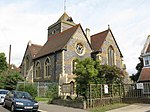
Church of St John the Evangelist Coulsdon Church 1250 20 May 1954 TQ3127358187
51°18′28″N 0°07′05″W / 51.307669°N 0.118088°W / 51.307669; -0.118088 (Church of St John the Evangelist)
1188464
Church of St John the Evangelist
More images
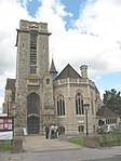
Church of St Mary Addington Croydon Church 1080 29 January 1951 TQ3710463991
51°21′30″N 0°01′56″W / 51.358453°N 0.032254°W / 51.358453; -0.032254 (Church of St Mary Addington)
1079343
Church of St Mary Addington
More images
Hospital of the Holy Trinity (Whitgift Hospital) Croydon Almshouses 1599 29 January 1951 TQ3232565584
51°22′26″N 0°06′01″W / 51.373901°N 0.100258°W / 51.373901; -0.100258 (Hospital of the Holy Trinity (Whitgift Hospital))
1188846
Hospital of the Holy Trinity (Whitgift Hospital)
More images
Old Palace School (Croydon Palace) Croydon Archbishop's palace 15th century 29 January 1951 TQ3197065392
51°22′20″N 0°06′20″W / 51.372258°N 0.105427°W / 51.372258; -0.105427 (Old Palace School (Croydon Palace))
1079296
Old Palace School (Croydon Palace)
More images
Church of St John the Baptist Croydon Church 15th century 29 January 1951 TQ3193665440
51°22′22″N 0°06′21″W / 51.372697°N 0.105897°W / 51.372697; -0.105897 (Church of St John the Baptist)
1079319
Church of St John the Baptist
More images
Church of St Michael and All Angels Croydon Church 1880–85 20 May 1954 TQ3226366068
51°22′42″N 0°06′03″W / 51.378265°N 0.100968°W / 51.378265; -0.100968 (Church of St Michael and All Angels)
1079297
Church of St Michael and All Angels
More images

Grade II*

Name Location Type Completed Date designated Grid ref.
Geo-coordinates
Entry number Image
Addington Palace (Royal School of Church Music) Croydon House 1772 29 January 1951 TQ3636963609
51°21′19″N 0°02′35″W / 51.355197°N 0.04295°W / 51.355197; -0.04295 (Addington Palace (Royal School of Church Music))
1358819
Addington Palace (Royal School of Church Music)
More images
Airport House Croydon Airport terminal 1928 1 August 1978 TQ3116663615
51°21′23″N 0°07′03″W / 51.356474°N 0.11762828°W / 51.356474; -0.11762828 (Airport House)
1188970
Airport House
Airport House
More images
Church of St Augustine Croydon Church 1881–84 29 October 1976 TQ3242463237
51°21′10″N 0°05′59″W / 51.352786°N 0.09971°W / 51.352786; -0.09971 (Church of St Augustine)
1079301
Church of St Augustine
More images
Church of St James Croydon Church 1829 29 October 1976 TQ3266766451
51°22′54″N 0°05′42″W / 51.381613°N 0.095024°W / 51.381613; -0.095024 (Church of St James)
1294484
Church of St James
Church of St James
More images
St John the Evangelist Upper Norwood Church 1878–87 29 October 1976 TQ3360969805
51°24′42″N 0°04′49″W / 51.411533°N 0.080235°W / 51.411533; -0.080235 (St John the Evangelist)
1079275
St John the Evangelist
More images
Church of St Mary Magdalene Addiscombe Church 1868 29 October 1976 TQ3353166011
51°22′39″N 0°04′58″W / 51.377456°N 0.082782°W / 51.377456; -0.082782 (Church of St Mary Magdalene)
1358794
Church of St Mary Magdalene
More images
Church of the Holy Innocents, and boundary wall Croydon Church 1894–95 29 November 1976 TQ3369768196
51°23′49″N 0°04′46″W / 51.397053°N 0.079576°W / 51.397053; -0.079576 (Church of the Holy Innocents, and boundary wall)
1079303
Church of the Holy Innocents, and boundary wall
More images
Wrencote House Croydon House Late 17th century 29 January 1951 TQ3238265149
51°22′12″N 0°05′59″W / 51.369978°N 0.099602°W / 51.369978; -0.099602 (Wrencote House)
1079291
Wrencote House
Wrencote House
More images
Croydon War Memorial Croydon War memorial 1921 19 November 1973 TQ3239265405
51°22′20″N 0°05′58″W / 51.372277°N 0.099362791°W / 51.372277; -0.099362791 (Croydon War Memorial)
1268438
Croydon War Memorial
More images

Notes

  1. ^ The date given is the date used by Historic England as significant for the initial building or that of an important part in the structure's description.
  2. ^ Sometimes known as OSGB36, the grid reference is based on the British national grid reference system used by the Ordnance Survey.
  3. ^ The "List Entry Number" is a unique number assigned to each listed building and scheduled monument by Historic England.

External links

London Borough of Croydon
Districts

Location of the London Borough of Croydon in Greater London
Attractions
Street markets
Parks and
open spaces
Constituencies
Wards
Rail stations
and tram stops
Art and architecture
Other topics
Grade I listed buildings in London
Grade II* listed buildings in London
Portals: Categories: