Name
Location
Type
Completed Date designated
Grid ref. Entry number Image
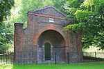
Charnel House to Church of St Nicholas
Greenwich Charnel House
1697
19 October 1951
TQ3739777722 51°28′54″N 0°01′22″W / 51.481772°N 0.022731°W / 51.481772; -0.022731 (Charnel House to Church of St Nicholas)
1289734 Charnel House to Church of St Nicholas More images
Church of St Luke
Charlton Church
Earlier church
19 October 1951
TQ4145777835 51°28′54″N 0°02′09″E / 51.481788°N 0.035744°E / 51.481788; 0.035744 (Church of St Luke)
1358934 Church of St Luke More images
Church of St Mary Magdalene
Woolwich Church
1727–1739
26 March 1954
TQ4306879124 51°29′35″N 0°03′34″E / 51.492965°N 0.05945°E / 51.492965; 0.05945 (Church of St Mary Magdalene)
1358969 Church of St Mary Magdalene More images
Church of St Michael and All Angels
Blackheath Church
1828–1830
8 June 1973
TQ3996975896 51°27′53″N 0°00′49″E / 51.464734°N 0.013562°E / 51.464734; 0.013562 (Church of St Michael and All Angels)
1079055 Church of St Michael and All Angels More images
Church of St Nicholas
Greenwich Church
13th century
19 October 1951
TQ3739677745 51°28′55″N 0°01′22″W / 51.481979°N 0.022736°W / 51.481979; -0.022736 (Church of St Nicholas)
1358943 Church of St Nicholas More images
Church of St Nicholas (Plumstead)
Plumstead Church
Medieval
26 March 1954
TQ4593178545 51°29′13″N 0°06′02″E / 51.487032°N 0.100422°E / 51.487032; 0.100422 (Church of St Nicholas (Plumstead))
1211745 Church of St Nicholas (Plumstead) More images
Cliefden House
Eltham House
Early 18th century
26 March 1954
TQ4282374437 51°27′03″N 0°03′15″E / 51.450911°N 0.05403°E / 51.450911; 0.05403 (Cliefden House)
1358945 Cliefden House More images
Eltham Court (Eltham Palace )
Eltham Royal Palace
Medieval
6 July 1981
TQ4245874010 51°26′50″N 0°02′55″E / 51.447166°N 0.048609°E / 51.447166; 0.048609 (Eltham Court (Eltham Palace))
1212906 Eltham Court (Eltham Palace )
Garden Wall to South of Moat of Well Hall Art Gallery
Eltham Garden Wall
26 March 1954
TQ4244475071 51°27′24″N 0°02′56″E / 51.456703°N 0.048835°E / 51.456703; 0.048835 (Garden Wall to South of Moat of Well Hall Art Gallery)
1212111 Garden Wall to South of Moat of Well Hall Art Gallery More images
Granada Cinema
Woolwich Cinema
1936–1937
31 December 1973
TQ4323679160 51°29′36″N 0°03′43″E / 51.493246°N 0.061883°E / 51.493246; 0.061883 (Granada Cinema)
1212651 Granada Cinema More images
Main Building, Royal Military Academy
Woolwich Barracks
1805–1808
8 June 1973
TQ4307877208 51°28′33″N 0°03′32″E / 51.475746°N 0.058818°E / 51.475746; 0.058818 (Main Building, Royal Military Academy)
1358936 Main Building, Royal Military Academy More images
Manna Mead
Greenwich House
c. 1800
19 October 1951
TQ3844176812 51°28′24″N 0°00′29″W / 51.47334°N 0.008062°W / 51.47334; -0.008062 (Manna Mead)
1212237 Manna Mead More images
Moat and Bridge to South of Well Hall Art Gallery
Eltham Moat
16th century
26 March 1954
TQ4243975110 51°27′25″N 0°02′56″E / 51.457055°N 0.048779°E / 51.457055; 0.048779 (Moat and Bridge to South of Well Hall Art Gallery)
1212110 Moat and Bridge to South of Well Hall Art Gallery More images
North and East Walls to Churchyard of St Nicholas and Gate Piers on West Wall
Greenwich Gate Pier
1697
8 June 1973
TQ3740077772 51°28′56″N 0°01′22″W / 51.482221°N 0.022668°W / 51.482221; -0.022668 (North and East Walls to Churchyard of St Nicholas and Gate Piers on West Wall)
1219793 North and East Walls to Churchyard of St Nicholas and Gate Piers on West Wall More images
North Boundary Wall of No. 20 Court Road
Eltham Boundary Wall
Early 16th century
8 June 1973
TQ4265174110 51°26′53″N 0°03′05″E / 51.448016°N 0.051425°E / 51.448016; 0.051425 (North Boundary Wall of No. 20 Court Road)
1291771 North Boundary Wall of No. 20 Court Road
No. 32 and 32A Court Yard
Eltham Building
Late 16th century
8 June 1973
TQ4248474112 51°26′53″N 0°02′56″E / 51.448076°N 0.049024°E / 51.448076; 0.049024 (No. 32 and 32A Court Yard)
1079040 Upload Photo
No. 47 and 49 Maze Hill
Greenwich House
Early 18th century
5 April 1954
TQ3916377773 51°28′54″N 0°00′10″E / 51.481799°N 0.002705°E / 51.481799; 0.002705 (No. 47 and 49 Maze Hill)
1078940 No. 47 and 49 Maze Hill More images
No. 20 Blackheath Park
Blackheath Detached House
1957–1958
29 March 1988
TQ3998875844 51°27′51″N 0°00′50″E / 51.464262°N 0.013815°E / 51.464262; 0.013815 (No. 20 Blackheath Park)
1213442 Upload Photo
No. 34, 36 and 38 Court Yard
Eltham Timber Framed Building
16th century
8 June 1973
TQ4247574106 51°26′53″N 0°02′56″E / 51.448024°N 0.048893°E / 51.448024; 0.048893 (No. 34, 36 and 38 Court Yard)
1218878 Upload Photo
No. 6, 8, 10 and 12 Including Forecourt Piers in Front and Walls
Greenwich Terrace
Early 18th century
19 October 1951
TQ3841977454 51°28′45″N 0°00′29″W / 51.479115°N 0.008127°W / 51.479115; -0.008127 (No. 6, 8, 10 and 12 Including Forecourt Piers in Front and Walls)
1218993 No. 6, 8, 10 and 12 Including Forecourt Piers in Front and Walls More images
No. 85-91 Genesta Road and Attached Walls Gates and Gatepiers
Woolwich Garage
1933
12 October 1978
TQ4418277570 51°28′43″N 0°04′29″E / 51.478719°N 0.074851°E / 51.478719; 0.074851 (No. 85-91 Genesta Road and Attached Walls Gates and Gatepiers)
1247069 No. 85-91 Genesta Road and Attached Walls Gates and Gatepiers More images
Old brick wall between gardens in front of No. 34 and 36 Court Yard and along road frontage of these houses
Eltham Wall
16th century
8 June 1973
TQ4248174090 51°26′52″N 0°02′56″E / 51.447879°N 0.048972°E / 51.447879; 0.048972 (Old brick wall between gardens in front of No. 34 and 36 Court Yard and along road frontage of these houses)
1358957 Upload Photo
Orangery to former Eltham House, now at north end of grounds of No. 113 Eltham High Street
Eltham Orangery
Late 17th century
26 March 1954
TQ4284074575 51°27′08″N 0°03′16″E / 51.452147°N 0.054331°E / 51.452147; 0.054331 (Orangery to former Eltham House, now at north end of grounds of No. 113 Eltham High Street)
1079017 Upload Photo
Outer Courtyard Walls to West and South of Vanbrugh Castle
Maze Hill , Greenwich Gate Pier
Early 18th century
8 June 1973
TQ3930977582 51°28′48″N 0°00′17″E / 51.480047°N 0.004731°E / 51.480047; 0.004731 (Outer Courtyard Walls to West and South of Vanbrugh Castle)
1078944 Outer Courtyard Walls to West and South of Vanbrugh Castle More images
Paragon House
Blackheath House
Late 18th century
19 October 1951
TQ3990676436 51°28′11″N 0°00′46″E / 51.469602°N 0.012869°E / 51.469602; 0.012869 (Paragon House)
1289733 Paragon House More images
Point House
Greenwich House
1701
8 June 1973
TQ3841976821 51°28′24″N 0°00′30″W / 51.473427°N 0.008375°W / 51.473427; -0.008375 (Point House)
1289615 Point House More images
Royal Arsenal , Dial Square Entrance Range
Woolwich Gate
1717–1720
8 June 1973
TQ4379479093 51°29′33″N 0°04′12″E / 51.492503°N 0.069888°E / 51.492503; 0.069888 (Royal Arsenal, Dial Square Entrance Range)
1211005 Royal Arsenal , Dial Square Entrance RangeMore images
Royal Arsenal , Board Room (Old Royal Military Academy)
Woolwich Pattern Shop
After 1806
8 June 1973
TQ4371279266 51°29′39″N 0°04′08″E / 51.494078°N 0.068778°E / 51.494078; 0.068778 (Royal Arsenal, Board Room (Old Royal Military Academy))
1359015 Royal Arsenal , Board Room (Old Royal Military Academy)More images
Royal Arsenal , the Grand Store (West and South Ranges: Buildings 36 37 and 46; E Range: building 49)
Woolwich Arsenal
1808–1813
8 June 1973
TQ4404979312 51°29′40″N 0°04′25″E / 51.494406°N 0.073648°E / 51.494406; 0.073648 (Royal Arsenal, the Grand Store (West and South Ranges: Buildings 36 37 and 46; E Range: building 49))
1078958 Royal Arsenal , the Grand Store (West and South Ranges: Buildings 36 37 and 46; E Range: building 49)More images
Royal Artillery Barracks , Main Building
Woolwich Barracks
1775–1782
8 June 1973
TQ4310478322 51°29′09″N 0°03′35″E / 51.48575°N 0.059643°E / 51.48575; 0.059643 (Royal Artillery Barracks, Main Building)
1078918 Royal Artillery Barracks , Main BuildingMore images
Severndroog Castle
Castle Wood Park, Shooter's Hill
House
1784
26 March 1954
TQ4319076196 51°28′00″N 0°03′36″E / 51.466624°N 0.06002°E / 51.466624; 0.06002 (Severndroog Castle)
1289792 Severndroog Castle More images
Stretch of Old Wall Running East from South East Angle of Gate House Garden
Eltham Wall
16th century
8 June 1973
TQ4260773996 51°26′49″N 0°03′03″E / 51.447003°N 0.050746°E / 51.447003; 0.050746 (Stretch of Old Wall Running East from South East Angle of Gate House Garden)
1218860 Upload Photo
The Borough Hall and Meridian House
Greenwich 1939
13 November 1990
TQ 38235 77334
1213855 The Borough Hall and Meridian HouseMore images
The Manor House
Eltham House
1695
19 October 1951
TQ3864877075 51°28′32″N 0°00′18″W / 51.475653°N 0.00498°W / 51.475653; -0.00498 (The Manor House)
1358942 The Manor House
The Presbytery
Greenwich Priests House
c. 1630
19 October 1951
TQ3857477170 51°28′35″N 0°00′22″W / 51.476525°N 0.006008°W / 51.476525; -0.006008 (The Presbytery)
1079011 The Presbytery More images
The Rotunda
Woolwich Garden Building
1814
8 June 1973
TQ4265078139 51°29′03″N 0°03′11″E / 51.48422°N 0.053035°E / 51.48422; 0.053035 (The Rotunda)
1078987 The Rotunda More images
The Standard Reservoir Conduit House
Greenwich Park , Greenwich Conduit House
Late 17th century or early 18th century
25 September 2009
TQ3863277246 51°28′38″N 0°00′19″W / 51.477194°N 0.005143°W / 51.477194; -0.005143 (The Standard Reservoir Conduit House)
1393455 The Standard Reservoir Conduit House More images
The Woodlands
Westcombe Park House
1772
19 October 1951
TQ4011277556 51°28′47″N 0°00′59″E / 51.479615°N 0.016277°E / 51.479615; 0.016277 (The Woodlands)
1078946 The Woodlands More images
Trinity Hospital
Greenwich Courtyard
1613–1617
19 October 1951
TQ3882978150 51°29′07″N 0°00′07″W / 51.485269°N 0.001954°W / 51.485269; -0.001954 (Trinity Hospital)
1078961 Trinity Hospital More images
Wall along frontage of No. 32 and 32a Court Yard, and along north boundary of garden from front to rear
Eltham Wall
16th century
8 June 1973
TQ4249474139 51°26′54″N 0°02′57″E / 51.448316°N 0.049179°E / 51.448316; 0.049179 (Wall along frontage of No. 32 and 32a Court Yard, and along north boundary of garden from front to rear)
1079039 Upload Photo
Wall running 187 yards along west side of road from north east corner of No. 1 Court Yard to north east corner of Bramber House
Eltham Wall
16th century
8 June 1973
TQ4261774231 51°26′57″N 0°03′04″E / 51.449112°N 0.050985°E / 51.449112; 0.050985 (Wall running 187 yards along west side of road from north east corner of No. 1 Court Yard to north east corner of Bramber House)
1358956 Wall running 187 yards along west side of road from north east corner of No. 1 Court Yard to north east corner of Bramber House More images
Walls Surrounding Garden of the Gate House
Eltham Gate Pier
Late 17th century
8 June 1973
TQ4251974077 51°26′52″N 0°02′58″E / 51.447753°N 0.049514°E / 51.447753; 0.049514 (Walls Surrounding Garden of the Gate House)
1079038 Upload Photo
Walls to North of Front Garden of Bramber House and Along Road Front
Eltham Wall
16th century
8 June 1973
TQ4252974111 51°26′53″N 0°02′59″E / 51.448056°N 0.049671°E / 51.448056; 0.049671 (Walls to North of Front Garden of Bramber House and Along Road Front)
1291744 Upload Photo
Well Hall Art Gallery
Eltham Restaurant
1936
26 March 1954
TQ4245675107 51°27′25″N 0°02′56″E / 51.457024°N 0.049022°E / 51.457024; 0.049022 (Well Hall Art Gallery)
1289673 Well Hall Art Gallery More images
Woolwich Town Hall
Woolwich Town Hall
1902–1906
8 June 1973
TQ4345278739 51°29′22″N 0°03′53″E / 51.489409°N 0.064821°E / 51.489409; 0.064821 (Woolwich Town Hall)
1289668 Woolwich Town Hall More images
 Media related to Grade I listed buildings in the Royal Borough of Greenwich at Wikimedia Commons
 Media related to Grade II* listed buildings in the Royal Borough of Greenwich at Wikimedia Commons