Human settlement in England
| Great Habton | |
|---|---|
 | |
 | |
| Civil parish | |
| Unitary authority | |
| Ceremonial county | |
| Region | |
| Country | England |
| Sovereign state | United Kingdom |
| 54°10′37″N 0°50′21″W / 54.176833°N 0.83920630°W / 54.176833; -0.83920630 | |
Great Habton is a village and former civil parish about 18 miles from York, now in the parish of Habton, in the Ryedale district, in the county of North Yorkshire, England. In 1961 the parish had a population of 103.
Amenities
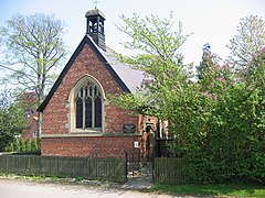
Great Habton has a church called St Chad and a pub called The Grapes Inn.
History
The name "Habton" means 'Hab(b)a's farm/settlement'. Great Habton was recorded in the Domesday Book as Abbetune/Abetune/Habetun. Great Habton was formerly a township in the parish of Kirby Misperton, from 1866 Great Habton was a civil parish in its own right, on 1 April 1986 the parish was abolished and merged with Little Habton and Ryton to form Habton.
See also
References
- "Population statistics Great Habton CP/Tn through time". A Vision of Britain. Retrieved 8 October 2020.
- "St. Chad's, Great Habton". Kirby Misperton & Middleton parishes. Retrieved 8 October 2020.
- "The Grapes Inn, Great Habton". The Grapes Inn, Great Habton. Retrieved 8 October 2020.
- "Great and Little Habton Key to English Place-names". University of Nottingham. Retrieved 7 October 2020.
- "Place name: Great Habton, Yorkshire Folio". The National Archives. Retrieved 8 October 2020.
- "Parishes: Kirkby Misperton". British History Online. Retrieved 8 October 2020.
- "Relationships and changes Great Habton CP/Tn through time". A Vision of Britain through Time. Retrieved 8 October 2020.
- "The Ryedale (Parishes) Order 1985" (PDF). Local Government Boundary Commission for England. Archived from the original (PDF) on 23 February 2022. Retrieved 13 December 2021.
External links
This Ryedale location article is a stub. You can help Misplaced Pages by expanding it. |