| Haterk Հաթերք | |
|---|---|
| Həsənriz | |
 | |
  | |
| Coordinates: 40°10′04″N 46°31′04″E / 40.16778°N 46.51778°E / 40.16778; 46.51778 | |
| Country | |
| • District | Aghdara |
| Elevation | 1,120 m (3,670 ft) |
| Population | |
| • Total | 1,638 |
| Time zone | UTC+4 (AZT) |
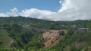
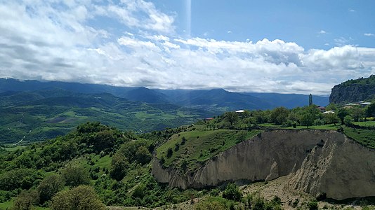
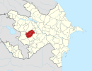
Haterk (Armenian: Հաթերք) or Hasanriz (Azerbaijani: Həsənriz) is a village in the Aghdara District of Azerbaijan, in the region of Nagorno-Karabakh. Until 2023 it was controlled by the breakaway Republic of Artsakh. The village had an ethnic Armenian-majority population until the exodus of the Armenian population of Nagorno-Karabakh following the 2023 Azerbaijani offensive in Nagorno-Karabakh.
History

After the Battle of Manzikert in 1071, the Seljuks conquered most of the remnants of Bagratid Armenia, which had been largely annexed by the Byzantine Empire in the 11th century. The Syunik, Khachen (Artsakh) and Tashir principalities remained unconquered however. The Syunik and Khachen principalities had close ties, their royal families intermarried, and their respective principalities functioned as refuges and bastions for each other during times of need. During the end of the 12th century, Seljuk power declined, and forces of the Georgian-Armenian Zakarian princes moved southwards and established Zakarid Armenia. During this period, the Armenian principalities of the region consisted of the three branches of Khachen: Tsar, Haterk and Khokhanaberd (with their spiritual center at Gandzasar) along with the Khaghbakian family in northern Syunik (Vayots Dzor). The Armenian princes of Haterk (Upper Khachen) were established on the left bank of the Tartar River, with their spiritual center being at Dadivank, the principal church of which was established by Arzu-Khatun, the wife of Vakhtang of Haterk. Prince Hasan of Haterk left an inscription at Dadivank in 1182. The leading family among the three Khachen princes was the one from Haterk. Vakhtang of Haterk contributed in 1191 to the building of the Nor Getik monastery (present day Goshavank in northeastern Armenia). In the 15th century, Artsakh was subjugated by the Turkmen tribes of Qara Qoyunlu and Aq Qoyunlu, and Haterk was destroyed. Its inhabitants founded the modern village close to the original settlement in the 16th century. In 1603, the Persians established a protectorate over the Melikdoms of Karabakh and sponsored the establishment of a local khanate in 1750.
During the Soviet period, Haterk was a part of the Mardakert District in the Nagorno-Karabakh Autonomous Oblast of the Azerbaijan SSR. Haterk came under the control of Armenian forces during the First Nagorno-Karabakh War and subsequently became part of the Martakert Province of the Republic of Artsakh. After the 2020 Nagorno-Karabakh war, 157 displaced people settled in the village.
Historical heritage sites
Haterk can be divided into three historical parts, Shen or Pap – the village center, Kyok and Mtghaser. There are several historical and cultural heritage sites in and around Haterk, including the ruined St. Nshan Church (Armenian: Սուրբ Նշան եկեղեցի, romanized: Surb Nshan Yekeghetsi), the chapel of Astghablur (Armenian: Աստղաբլուր) and an oil mill from the Middle Ages, the monastery of Mesis (Armenian: Մեսիս), the ruined village of Khotorashen (Armenian: Խոտորաշեն), a chapel-tomb and khachkars from between the 12th and 13th centuries, a 19th/20th-century fortress, and the 19th-century church of Surb Astvatsatsin (Armenian: Սուրբ Աստվածածին, lit. 'Holy Mother of God') in the center of Haterk, the only one of the three churches in Haterk that still stands.
Economy and culture
The population is mainly engaged in agriculture and animal husbandry. As of 2015, the village has a municipal building, a house of culture, a medical centre, a secondary school, a kindergarten, and 19 shops. The village hosts a yearly Zhingyalov hats festival since 2018.
Demographics
Haterk had 1,531 inhabitants in 2005, and 1,638 inhabitants in 2015. The population of the village was estimated to be 1,800 inhabitants in 2021.
Gallery
References
- ^ Hakob Ghahramanyan. "Directory of socio-economic characteristics of NKR administrative-territorial units (2015)".
- Андрей Зубов. "Андрей Зубов. Карабах: Мир и Война". drugoivzgliad.com.
- Sauer, Pjotr (2 October 2023). "'It's a ghost town': UN arrives in Nagorno-Karabakh to find ethnic Armenians have fled". The Guardian. ISSN 0261-3077. Retrieved 9 November 2023.
- ^ Levon Chorbajian, Patrick Donabédian, Claude Mutafian (1994). The Caucasian Knot: The History & Geopolitics of Nagorno-Karabagh. ISBN 9781856492881.
{{cite book}}: CS1 maint: multiple names: authors list (link) - Վահրամ Բալայան (2020). Արցախի Հանրապետության բնակավայրերի պատմության ուրվագծեր (in Armenian). Զանգակ հրատարակչություն.
- Parry, Ken; David J. Melling; Dimitry Brady; Sidney H. Griffith; John F. Healey (December 5, 2001). The Blackwell Dictionary of Eastern Christianity. Wiley-Blackwell. pp. 335–336. ISBN 0-631-23203-6.
- ^ Artsakh Press (2021-12-20). "38 displaced families settled in Haterk. Community Leader".
- Kiesling, Brady; Kojian, Raffi (2019). Rediscovering Armenia: An in-depth inventory of villages and monuments in Armenia and Artsakh (3rd ed.). Armeniapedia Publishing.
- Artsakh Press (2019-05-11). "The Second Zhengyalov Hats Festival was held in Haterk, Artsakh Republic (Photos)".
- "The Results of the 2005 Census of the Nagorno-Karabakh Republic" (PDF). National Statistic Service of the Republic of Artsakh. Archived from the original (PDF) on 2011-03-02. Retrieved 2009-03-07.
External links
| Martakert Province | ||
|---|---|---|
| Capital: Martakert | ||
| Urban communities |  | |
| Rural communities |
| |
| Not under Artsakh control | ||


