| Hualcán | |
|---|---|
| Rajopaquinan | |
 | |
| Highest point | |
| Elevation | 6,165 m (20,226 ft) |
| Prominence | 2,912 m (9,554 ft) |
| Parent peak | Huascaran |
| Coordinates | 9°12′09.89″S 077°31′08.75″W / 9.2027472°S 77.5190972°W / -9.2027472; -77.5190972 |
| Geography | |
 | |
| Location | Ancash, Peru |
| Parent range | Andes, Cordillera Blanca |
| Climbing | |
| First ascent | August 1939 via South Ridge by Karl Schmid and Siegfried Rohrer (Germany) S. flank-1979. |
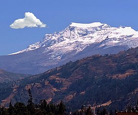
Hualcán (also called Rajopaquinan) (possibly from Quechua wallqa, walqa, -n a suffix) is a mountain in the Cordillera Blanca in the Andes of Peru, about 6,165 metres (20,226 ft) high. It is located in Ancash, between Chacas (in Asunción Province) and Carhuaz (Carhuaz Province) districts. Hualcán lies south-east of Chequiaraju. Its territory is within the Peruvian protection area of Huascarán National Park and it's on the border of two provinces: Asuncion and Carhuaz. Cities of Chacas and Carhuaz.
First Ascent
Hualcan was first climbed by Karl Schmid and Siegfried Rohrer (Germany) in August 1939.
Elevation
Other data from available digital elevation models: SRTM yields 6157 metres and ASTER 6157 metres. The height of the nearest key col is 3253 meters, leading to a topographic prominence of 2912 meters. Hualcan is considered a Mountain Sub-System according to the Dominance System and its dominance is 47.23%. Its parent peak is Huascaran Sur and the Topographic isolation is 13 kilometers.
External links
References
- "Hualcan / Rajopaquinan". Andes Specialists. Retrieved 2020-04-12.
- ^ Deutsch-Österreichische Alpenvereins expeditionen in den Peruanischen Anden.
- ^ "AAJ (American Alpine Journal)". AAJ (American Alpine Journal): 157. 1941.
- Neate, Jill (1994). Mountaineering in the Andes. RGS-IBG Expedition Advisory Centre, 2nd edition
- ^ Biggar, John (2005). The Andes: A Guide for Climbers. Andes. p. 77. ISBN 9780953608720.
- ^ Peru 1:100 000, Carhuás (19-h). IGN (Instituto Geográfico Nacional - Perú).
- Alpenvereinskarte 0/3a. Cordillera Blanca Nord (Peru). 1:100 000. Oesterreichischer Alpenverein. 2005. ISBN 3-928777-57-2.
- Teofilo Laime Ajacopa, Diccionario Bilingüe Iskay simipi yuyayk'ancha, La Paz, 2007 (Quechua-Spanish dictionary): wallqa - s. Collar. Adorno que se lleva alrededor del cuello.
- Diccionario Quechua - Español - Quechua, Academía Mayor de la Lengua Quechua, Gobierno Regional Cusco, Cusco 2005: walqa - s. Collar, collarín. || Colgandijo de oro y piedras preciosas, como la turquesa y otros, usado por la nobleza inka. || Bolsa colgante al hombro. SINÓN: wallqha, walqha. Bol: Sarta de cuentas, collar o cadena. Ec: wallka.
- escale.minedu.gob.pe - UGEL Map of the Asunción Province (Ancash Region)
- Biggar, John (2020). The Andes a guide for climbers (5th ed.). Castle Douglas, Scotland. ISBN 978-0-9536087-7-5. OCLC 1260820889.
{{cite book}}: CS1 maint: location missing publisher (link) - PERU, Autor: GEO GPS. "Base de datos Perú - Shapefile - *.shp - MINAM - IGN - Límites Políticos". Retrieved 2020-04-30.
- USGS, EROS Archive. "USGS EROS Archive - Digital Elevation - SRTM Coverage Maps". Retrieved 12 April 2020.
- "ASTER GDEM Project". ssl.jspacesystems.or.jp. Retrieved 2020-04-14.
- ^ "Hualcan / Rajopaquinan". Andes Specialists. Retrieved 2020-04-12.
- "Dominance - Page 2". www.8000ers.com. Retrieved 2020-04-12.
This Ancash Region geography article is a stub. You can help Misplaced Pages by expanding it. |