| Kâhta District | |
|---|---|
| District | |
 The Karakuş Tumulus is a monumental tomb of Royal Family of Commagene located in the district. The Karakuş Tumulus is a monumental tomb of Royal Family of Commagene located in the district. | |
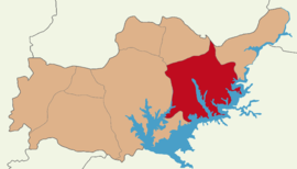
 Map showing Kâhta District in Adıyaman Province Map showing Kâhta District in Adıyaman Province | |
 | |
| Coordinates: 37°47′N 38°37′E / 37.783°N 38.617°E / 37.783; 38.617 | |
| Country | Turkey |
| Province | Adıyaman |
| Seat | Kâhta |
| Government | |
| • Kaymakam | Selami Korkutata |
| Area | 1,274 km (492 sq mi) |
| Population | 127,534 |
| • Density | 100/km (260/sq mi) |
| Time zone | UTC+3 (TRT) |
Kâhta District is a district of Adıyaman Province of Turkey. Its seat is the town Kâhta. Its area is 1,274 km, and its population is 127,534 (2021). On 12 October 2018, cave drawings which date back to the Paleolithic era, were discovered in the Kâhta district, due to the decline of Atatürk Reservoir waters by 10–15 meters.
Composition
There are 3 municipalities in Kâhta District:
There are 102 villages in Kâhta District:
- Adalı
- Akalın
- Akdoğan
- Akkavak
- Akkuş
- Aktaş
- Akyıldız
- Alidam
- Arılı
- Aydınpınar
- Bağbaşı
- Bağözü
- Ballı
- Belenli
- Belören
- Beşikli
- Boğazkaya
- Bostanlı
- Bozpınar
- Boztarla
- Burmapınar
- Büyükbağ
- Büyükbejyan
- Büyükbey
- Çakıreşme
- Çaltılı
- Çamlica
- Çardak
- Çataltepe
- Çaybaşı
- Çıralık
- Çukurtaş
- Cumhuriyet
- Damlacık
- Dardağan
- Dikenli
- Doluca
- Dumlu
- Dut
- Eceler
- Ekinci
- Elbeyi
- Erikdere
- Erikli
- Esendere
- Eski Kâhta
- Eskitaş
- Fıstıklı
- Geldibuldu
- Göçeri
- Gökçe
- Gölgeli
- Güdülge
- Güzelçay
- Habipler
- Hacıyusuf
- Hamzalar
- Hasandiğin
- Hasköy
- İkizce
- Işıktepe
- İslamköy
- Karacaören
- Karadut
- Karaman
- Karataş
- Kavaklı
- Kayadibi
- Koçtepe
- Köseler
- Kozağaç
- Menzil
- Mülk
- Narince
- Narlıdere
- Narsırtı
- Oluklu
- Ortanca
- Ovacık
- Şahintepe
- Salkımbağı
- Sarısu
- Şenköy
- Sıraca
- Sırakaya
- Susuz
- Taşlıca
- Taşlıçay
- Teğmenli
- Teknecik
- Tuğlu
- Turanlı
- Tütenocak
- Ulupınar
- Yapraklı
- Yelkovan
- Yenice
- Yenikuşak
- Yeşilkaya
- Yolaltı
- Zeytin
- Ziyaret
Places of interest
- Nemrut Dağı or Mount Nemrut - now a national park, famous for the antique statuary on the summit, dating back to the Commagene Kingdom.
- Karakuş Tumulus, with a large statue of an eagle.
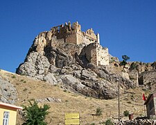
- Kâhta castle
- Severan Bridge, a Roman bridge.
-
Mount Nemrut
-
 Tumulus of Karakuş
-
 Kahta castle
-
 Severan Bridge
References
- ^ İlçe Belediyesi, Turkey Civil Administration Departments Inventory. Retrieved 12 January 2023.
- "İl ve İlçe Yüz ölçümleri". General Directorate of Mapping. Retrieved 12 January 2023.
- "Address-based population registration system (ADNKS) results dated 31 December 2021" (XLS) (in Turkish). TÜİK. Retrieved 12 January 2023.
- "Paleolithic art unveiled after dam water ebbs in Turkey's east". Hürriyet Daily News. 12 October 2018.
- Belde Belediyesi, Turkey Civil Administration Departments Inventory. Retrieved 13 January 2023.
- Köy, Turkey Civil Administration Departments Inventory. Retrieved 12 January 2023.
| Kâhta District in Adıyaman Province of Turkey | ||
|---|---|---|
| Districts |  | |
| Metropolitan municipalities are bolded. | ||
This geographical article about a location in Adıyaman Province, Turkey is a stub. You can help Misplaced Pages by expanding it. |
