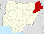
Village in Borno State, Nigeria
| Kogu | |
|---|---|
| village | |
 | |
| Coordinates: 10°25′06″N 11°56′55″E / 10.41833°N 11.94861°E / 10.41833; 11.94861 | |
| Country | |
| State | Borno State |
| LGA | Biu |
| Elevation | 344 m (1,128 ft) |
| Time zone | UTC+1 (WAT) |
Kogu is a large village in Biu LGA, of southwestern Borno State, in northeastern Nigeria. Kogu is located on a tributary of the Yangari River about 34 kilometres (21 mi) southwest of the town of Biu.
Mari Watirwa, the 20th Emir of Biu, established his capital at Kogu about 1795, after he drove the Fulani out of Biu. In 1838, his grandson, Emir Mari Biya, moved the capital to the town of Biu.
Notes
- Kogu (Approved) at GEOnet Names Server, United States National Geospatial-Intelligence Agency
- Nigeria topographic map, Series 1501 Air, NC-32-08 Gombe, Nigeria, Joint Operations Graphic (JOG) 1:250000 Scale, U.S. Army Map Service, 1967
- ^ Montgomery-Massingberd, Hugh (1980) "Biu" Burke's Royal Families of the World: Africa & the Middle East (Volume 2 of Burke's royal families of the world) Burke's Peerage, London, page 177, ISBN 0-85011-023-8
- Davies, J. G. (1954) The Biu book: a collation and reference book on Biu Division (Northern Nigeria) Norla, Zaria, Nigeria, page 38, OCLC 603775900
External links
- "Kogu Map — Satellite Images of Kogu" Maplandia World Gazetteer
| Local government areas |  | |
|---|---|---|
This Borno State, Nigeria location article is a stub. You can help Misplaced Pages by expanding it. |