| Kwai Chung | |||||||||||||||||
|---|---|---|---|---|---|---|---|---|---|---|---|---|---|---|---|---|---|
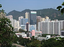
 Kwai Chung skyline in 2010 Kwai Chung skyline in 2010 | |||||||||||||||||
| Chinese | 葵涌 | ||||||||||||||||
| |||||||||||||||||

Kwai Chung is an urban area within Tsuen Wan New Town in the New Territories of Hong Kong. Together with Tsing Yi Island, it is part of the Kwai Tsing District of Hong Kong. It is also part of Tsuen Wan New Town.
In 2000, it had a population of 287,000. Its area is 9.93 km. Areas within Kwai Chung include: Kwai Fong, Kwai Hing, Lai King, Tai Wo Hau. Kwai Chung is the site of part of the container port of Hong Kong.
Origin of the name
In earlier times Kwai Chung was called Kwai Chung Tsai (葵涌子). Kwai Chung was a stream (Chung) that emptied into Gin Drinkers Bay (葵涌澳). The whole bay was reclaimed for land and the stream is no longer visible.
Divisions
Traditionally, Kwai Chung is divided into Sheung Kwai Chung (上葵涌; 'Upper Kwai Chung'), and Ha Kwai Chung (下葵涌; 'Lower Kwai Chung'). Administratively, the former is called North Kwai Chung, and the latter South Kwai Chung.
Sheung Kwai Chung, Chung Kwai Chung Village (中葵涌村) and Ha Kwai Chung Village (下葵涌村) are recognized villages under the New Territories Small House Policy.
Economy
Kwai Chung is the home of the principal commercial cargo handling area of Hong Kong, the Kwai Chung Container Terminal, one of the largest and busiest port facilities in the world. The main commercial port was relocated here from Yau Ma Tei in the 1980s, in preparation for the West Kowloon Reclamation, which has left the original waterfront of Yau Ma Tei almost half a mile inland.
The area has the head office of Kerry Logistics.
Education
- Lutheran School for the Deaf is in Kwai Chung.
- S.T.F.A. Lee Shau Kee College
Sheung Kwai Chung and Chung Kwai Chung (Upper and Central Kwai Chung) are in Primary One Admission (POA) School Net 64, which includes multiple aided schools (schools operated independently of the government but funded with government money); none of the schools in the net are government schools.
Ha Kwai Chung (Lower Kwai Chung) is in Primary One Admission (POA) School Net 65, which includes multiple aided schools; none of the schools in the net are government schools.
See also
- List of places in Hong Kong
- Public housing estates in Kwai Chung
- Hulu Concept, a not-for-profit cultural organisation based in Kwai Chung
References
- "List of Recognized Villages under the New Territories Small House Policy" (PDF). Lands Department. September 2009.
- "Contacts". Kerry Logistics. Retrieved 29 December 2020.
Global Head Office Kerry Logistics Network Limited 16/F Kerry Cargo Centre 55 Wing Kei Road Kwai Chung Hong Kong
- "POA School Net 64" (PDF). Education Bureau. Retrieved 27 September 2022.
- "POA School Net 65" (PDF). Education Bureau. Retrieved 27 September 2022.
External links
- Satellite view of the container port in Kwai Chung
- Delineation of area of existing village Sheung Kwai Chung (Tsuen Wan) for election of resident representative (2019 to 2022)
- Delineation of area of existing village Chung Kwai Chung (Tsuen Wan) for election of resident representative (2019 to 2022)
- Delineation of area of existing village Ha Kwai Chung (Tsuen Wan) for election of resident representative (2019 to 2022)
| Kwai Tsing District | |||
|---|---|---|---|
| Areas | |||
| Landmarks | |||
| Government | |||
| Education |
| ||
| Transport | |||
| This list is incomplete. | |||
| Urban areas of Hong Kong, Kowloon and New Territories | |||||||||||
|---|---|---|---|---|---|---|---|---|---|---|---|
| Hong Kong |
|  | |||||||||
| Kowloon |
| ||||||||||
| New Kowloon |
| ||||||||||
| New Territories |
| ||||||||||
| Official place names are summarized from "Geoinfo Map" of Government of Hong Kong Special Administrative Region, "Hong Kong Guide" of Lands Department, "Hong Kong Guide Book" of Universal Publications Ltd. and "Areas and Districts" of Rating and Valuation Department. M:Narrow meaning of urban areas KL: Kowloon Peninsula at the south of Boundary Street NKL: Former New Territories area at the north of Boundary Street and at the south of Lion Rock 1: Common definition (1) 2: Common definition (2) 3: Common definition (3) 4: Areas not adopting small house concessionary right of indigenous inhabitants 5: Jurisdiction area of former Urban Council 6: Definition of "Metropolitan Area" of Planning Department 7: Jurisdiction area of Urban Renewal Authority 8: Unique operating area of urban taxis 9: "Urban" (9a) and "Extended Urban" (9b) areas defined by Hong Kong Housing Authority 10: Definition of Urban rates 11: Hospital cluster belongs to Hong Kong or Kowloon 12: Police region belongs to Hong Kong or Kowloon 13: Regions having 999-year land lease 14: Geographical Constituency in Hong Kong Legislative Council belongs to Hong Kong or Kowloon 15: Regional Education Office belongs to Hong Kong or Kowloon 16: Primary One Admission School Net belongs to Hong Kong or Kowloon | |||||||||||
22°22′0″N 114°7′30″E / 22.36667°N 114.12500°E / 22.36667; 114.12500