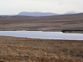
| Loch Achnamoine | |
|---|---|
 Loch Achnamoine, from the road on its northern shore Loch Achnamoine, from the road on its northern shore | |
 | |
| Location | Scottish Highlands |
| Coordinates | 58°15′40″N 4°01′21″W / 58.26111°N 4.02250°W / 58.26111; -4.02250 |
| Primary outflows | River Helmsdale |
| Basin countries | Scotland, United Kingdom |
| Max. length | 1.38 km (0.86 mi) |
| Max. width | 397 m (1,302 ft) |
| Surface elevation | 114.1 m (374 ft) |
Loch Achnamoine is a small mountain loch, situated on the River Helmsdale in the Highland council area of Scotland. The nearest settlement to it is Kinbrace, a small village 2.5 miles (4 km) east, along a small country road.
The name derives from the Scottish Gaelic elements "achadh" and "mòine", meaning "Lake of the Peat-field".
Loch Achnamoine is a drift dam, formed from the last glacial period in Scotland. The loch was the site of several biological surveys in the 1990s, identifying several species of xanthidium in its waters
References
- "The Gaelic origins of place names in Britain". OS GetOutside. Retrieved 9 November 2020.
- Memoirs of the Geological Society of Great Britain: Explanation of Sheet. Scotland. H.M. Stationery Office. 1931.
- Archiv Für Hydrobiologie: Monographische Beiträge. E. Schweizerbart. 1995.