| Longtou 龙头乡 | |
|---|---|
| Township | |
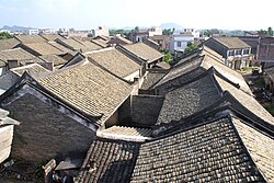
 Ancient Town in Longtou township Ancient Town in Longtou township | |
| Coordinates: 22°41′51″N 107°57′24″E / 22.69750°N 107.95667°E / 22.69750; 107.95667 | |
| Country | People's Republic of China |
| Region | Guangxi |
| Prefecture-level city | Chongzuo |
| County | Fusui |
| Village-level divisions | 1 residential communities 8 villages |
| Area | |
| • Total | 179.75 km (69.40 sq mi) |
| Population | |
| • Total | 32,000 |
| • Density | 180/km (460/sq mi) |
| Time zone | UTC+8 (China Standard) |
| Postal code | 532101 |
Longtou (simplified Chinese: 龙头乡; traditional Chinese: 龍頭鄉; pinyin: Lóngtóu Xiāng; zhuang: Lungzdouz Yangh) is a Township under the administration of Fusui County in southern Guangxi Zhuang Autonomous Region, China. As of 2011, it had an area of 179.75 square kilometres (69.40 sq mi) populated by 32,000 people residing in 1 residential communities (社区) and 8 villages.
Administrative divisions
There are 1 residential communities and 8 villages:
Residential communities:
- Longtou(龙头社区)
Villages:
- Tengguang(滕广村), Jiuzhuang(旧庄村), Fengzhuang(凤庄村), Xiaohan( 肖汉村), Natang(那塘村), Tanlong(坛龙村), Nagui(那贵村), Linwang(林旺村)
See also
References
- 2011年统计用区划代码和城乡划分代码:扶绥县 (in Chinese). National Bureau of Statistics of the People's Republic of China. Archived from the original on 2012-07-21. Retrieved 2013-01-08.
- 2011年统计用区划代码和城乡划分代码:龙头乡 (in Chinese). National Bureau of Statistics of the People's Republic of China. Archived from the original on February 19, 2013. Retrieved 2013-01-03.
- 2011年统计用区划代码和城乡划分代码:龙头乡 中华人民共和国国家统计局 National Bureau of Statistics of the People's Republic of China. Retrieved 2013-01-02.(in Chinese)
External links
- Longtou Township/Official website of Longtou(in Chinese)
This Guangxi location article is a stub. You can help Misplaced Pages by expanding it. |