| Hranice | |
|---|---|
| Town | |
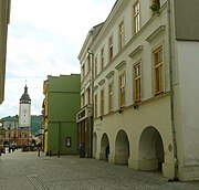
 Masarykovo Square with the old town hall Masarykovo Square with the old town hall | |
 Flag Flag Coat of arms Coat of arms | |
 | |
| Coordinates: 49°33′9″N 17°46′6″E / 49.55250°N 17.76833°E / 49.55250; 17.76833 | |
| Country | |
| Region | Olomouc |
| District | Přerov |
| Founded | 12th century |
| Government | |
| • Mayor | Daniel Vitonský |
| Area | |
| • Total | 49.78 km (19.22 sq mi) |
| Elevation | 250 m (820 ft) |
| Population | |
| • Total | 18,024 |
| • Density | 360/km (940/sq mi) |
| Time zone | UTC+1 (CET) |
| • Summer (DST) | UTC+2 (CEST) |
| Postal codes | 753 01, 753 54, 753 61 |
| Website | www |
Hranice (Czech pronunciation: [ˈɦraɲɪtsɛ]; German: Mährisch Weißkirchen) is a town in Přerov District in the Olomouc Region of the Czech Republic. It has about 18,000 inhabitants. The historic town centre is well preserved and is protected by law as an urban monument zone. The town is known for the Hranice Abyss.
Administrative parts
Hranice is made up of nine town parts and villages:
- Hranice I-Město
- Hranice II-Lhotka
- Hranice III-Velká
- Hranice IV-Drahotuše
- Hranice V-Rybáře
- Hranice VI-Valšovice
- Hranice VII-Slavíč
- Hranice VIII-Středolesí
- Hranice IX-Uhřínov
Středolesí and Uhřínov form an exclave of the municipal territory.
Etymology
The name Hranice literally means "border". It is sometimes called Hranice na Moravě ("Hranice in Moravia") to distinguish from other places with the same name.
Geography
Hranice is located about 22 kilometres (14 mi) northeast of Přerov and 33 km (21 mi) east of Olomouc. It lies mostly in the Moravian Gate lowland. The exclave of the municipal territory lies already in the Nízký Jeseník mountain range and contains the highest point of Hranice, which is the hill Studená at 626 metres (2,054 ft) above sea level. The Bečva River flows through the town.
The deepest pit cave in the Czech Republic, Hranice Abyss with a length of 473.5 metres (1,553 ft), is located by the town. With a water depth of 404 metres (1,325 ft), it is also the deepest flooded abyss in the world.
History

The first written mention of Hranice is in a falsificated document from 1169. According to the trusted sources, Hranice already existed at the end of the 12th century. In 1276, Hranice became a town. From the 1420s, the town became a property of the Cimburk family, and from 1499 a property of the Pernštejn family. In the 16th and 17th centuries, the estate often changed owners.
Until 1918, Hranice was part of Austria-Hungary in the district with the same name, one of the 34 Bezirkshauptmannschaften in Moravia.
In the days of Austria-Hungary, in the interbellum Czechoslovakia, and during the communist era the city hosted a large military academy. Notable graduates include Archduke Wilhelm of Austria and Herman Potočnik.
Jewish population

The first Jews came in 1611, receiving in 1637 the right for a self-governed Jewish quarter, where a maximum of 120 Jewish families were permitted to reside. Besides those 17 houses, located around the present Janáčkova street (renamed from Židovská street), they were not allowed to purchase houses elsewhere. In 1728, 115 families resided in the Jewish quarter and in 1789 the community had reached the maximum of 120 families. The community reached its peak of 802 people in 1857 (13% of the entire town). They had a significant role in the development of Hranice's industry: a textile plant established in 1844 (the largest factory until the mid-20th century), and distilleries (1827, 1836).
Demographics
|
|
| ||||||||||||||||||||||||||||||||||||||||||||||||||||||
| Source: Censuses | ||||||||||||||||||||||||||||||||||||||||||||||||||||||||
Economy

The largest employer in the town is SSI Schäfer, manufacturer of metal structures with more than 1,000 employees. Other notable employers with more than 500 employees are Henniges Hranice (manufacturer of rubber products for automotive industry), KROK CZ (manufacturer of work clothes), and Hranice Hospital.
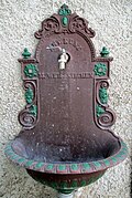
In 1883, Antonín Kunz founded a company in Hranice that specialized in the production of windpumps and other pumps. The company became the largest factory for water pumps in Austria-Hungary. At the end of the 19th century, it also produced complete communal water systems that were in towns and cities in the whole Austria-Hungary. The Sigma Pumps company developed out of Kunz's company.
Transport
Hranice lies on the railway from Přerov to Vsetín. The town is served by train stations Hranice na Moravě, Hranice na Moravě město, and Drahotuše. In the municipal territory is also located the Teplice nad Bečvou station, which serves this neighbouring municipality.
The D1 motorway leading from Přerov to Ostrava bypasses the town in the north.
Sights


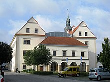
Since 1992, the historic town centre is protected as an urban monument zone. The church of the Beheading of Saint John the Baptist is the landmark of the town square. The construction was finished in 1763. It is a massive Baroque-Neoclassical building with valuable decorations of the interior. The second significant building on the square is the old town hall. It served its purpose until 1998, when the offices moved to the premises of the castle. Today it serves as a library, a museum, and a concert hall.
The Hranice Castle was formerly a Gothic castle of Cimburk lords. In 16th–17th centuries it was rebuilt in the Renaissance style. Today it serves as the town hall, museum and gallery.
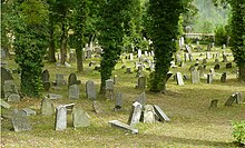
The Jewish community is commemorated by several monuments. The original small synagogue was replaced in 1863 by new larger building in Moorish-Byzantine style. It is used for cultural purposes. The Jewish cemetery was used until 1965. The oldest preserved tombstone is from 1685.
The most valuable technical monument are the Hranice Viaducts. The three viaducts are 430 metres (1,410 ft) long. The oldest one was built in 1844–1846.
Notable people
- Daniel Strejc-Vetterus (1592–1669), priest of the Unity of the Brethren
- Aaron Chorin (1766–1844), Hungarian rabbi
- Baruch Placzek (1834–1922), rabbi and author
- Isidore Singer (1859–1939), author and editor
- Franz Petrak (1886–1973), Austrian-Czech mycologist
- Albert Kutal (1904–1976), historian
- Helmut Otto Hofer (1912–1989), Austrian anatomist and zoologist
- Jiří Brdečka (1917–1982), writer
- Ivan Sviták (1925–1994), philosopher and poet
- Dalibor Janda (born 1962), singer
- Aleš Opata (born 1964), military leader
Twin towns – sister cities
See also: List of twin towns and sister cities in the Czech RepublicHranice is twinned with:
 Hlohovec, Slovakia
 Konstancin-Jeziorna, Poland
 Leidschendam-Voorburg, Netherlands
 Slovenske Konjice, Slovenia
See also
- The Confusions of Young Törless, a novel based on experience in the Hranice military academy
References
- "Population of Municipalities – 1 January 2024". Czech Statistical Office. 2024-05-17.
- "Hranická propast" (in Czech). Město Hranice. Retrieved 2021-05-31.
- ^ "Historie města" (in Czech). Město Hranice. Retrieved 2021-05-31.
- Die postalischen Abstempelungen auf den österreichischen Postwertzeichen-Ausgaben 1867, 1883 und 1890, Wilhelm Klein, 1967
- ^ Snyder, Timothy (28 September 2010). The Red Prince: The Secret Lives of a Habsburg Archduke. Basic Books. ISBN 978-0465018970. Retrieved 7 November 2013.
{{cite book}}: CS1 maint: date and year (link) - White, Lewis M. (2000). On all fronts: Czechs and Slovaks in World War II. East European Monographs. ISBN 9780880334563. Retrieved 7 November 2013.
- Gaďourek, Ivan (1953). The Political Control of Czechoslovakia: Study in Social Control of a Soviet Satellite State. Kroese. p. 72.
- Bednář, Václav; Pospěch, Tomáš (2007). Židé na Hranicku (PDF) (in Czech). DOST Hranice. pp. 2–5. ISBN 978-80-902942-3-3.
- ^ "Synagoga" (in Czech). Tourist Information Centre Hranice. Retrieved 2021-11-10.
- "Historický lexikon obcí České republiky 1869–2011" (in Czech). Czech Statistical Office. 2015-12-21.
- "Population Census 2021: Population by sex". Public Database. Czech Statistical Office. 2021-03-27.
- "Registr ekonomických subjektů". Business Register (in Czech). Czech Statistical Office. Retrieved 2023-05-20.
- "Company". Sigma Pumpy Hranice, Ltd. Retrieved 2021-11-10.
- ^ "Památky" (in Czech). Tourist Information Centre Hranice. Retrieved 2021-11-10.
- "Zámek" (in Czech). Muzeum Hranice. Retrieved 2021-05-31.
- "Židovský hřbitov" (in Czech). Tourist Information Centre Hranice. Retrieved 2021-11-10.
- "Partnerská města" (in Czech). Město Hranice. Retrieved 2020-08-29.