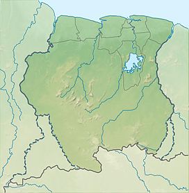
| Magneetrots | |
|---|---|
 Overhanging rock on the way to the top Overhanging rock on the way to the top | |
| Highest point | |
| Elevation | 310 m (1,020 ft) |
| Prominence | 130 m (430 ft) |
| Coordinates | 3°27′45″N 55°16′28″W / 3.4625°N 55.274444°W / 3.4625; -55.274444 |
| Geography | |
 | |
| Location | Sipaliwini District, Suriname |
| Climbing | |
| First ascent | 1904 |
Magneetrots is a mountain in the Sipaliwini District of Suriname. It measures 310 metres.
History
The Magneetrots as well as the Tebutop, the Roseveltpiek, and the Kasikasima were first explored in 1904 during the Tapanahony expedition.
On 16 August 1904, the expedition led by Alphons Franssen Herderschee [nl], made a first unsuccessful attempt at climbing the mountain. On 19 August, they tried again. Magnetic disturbances were observed by several expedition members, and therefore the mountain was named Magneetrots (English: magnet rock). The first part of the climb was a gentle slope upwards with many overhanging rocks, however near the top, there was a steep wall.
References
- ^ "Magneetrots". Peak Visor. Retrieved 26 February 2021.
- J.B.Ch. Wekker (1983). HISTORIE, TECHNIEKEN EN MAATSCHAPPELIJKE ACHTERGRONDEN DER KARTERINGSWERKZAAMHEDEN IN SURINAME SINDS 1667 (PDF). Rijkscommissie voor Geodesie. p. 104. ISBN 9061322286.
- Bruijning, Voorhoeve & Gordijn 1977, p. 395.
- Herderschee 1905, p. 45.
- Herderschee 1905, p. 46.
Bibliography
- Herderschee, A. Franssen (1905). Verslag der Tapanahoni-expeditie (in Dutch). Brill Publishers.
- Bruijning, Conrad Friederich Albert; Voorhoeve, Jan; Gordijn, W. (1977). Encyclopedie van Suriname (in Dutch). Amsterdam: Elsevier. p. 395. ISBN 9010018423.
This Suriname location article is a stub. You can help Misplaced Pages by expanding it. |