Rural municipality in Saskatchewan, Canada
| Leask No. 464 | |
|---|---|
| Rural municipality | |
| Rural Municipality of Leask No. 464 | |
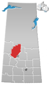
 Location of the RM of Leask No. 464 in Saskatchewan Location of the RM of Leask No. 464 in Saskatchewan | |
| Coordinates: 53°01′05″N 106°48′47″W / 53.018°N 106.813°W / 53.018; -106.813 | |
| Country | Canada |
| Province | Saskatchewan |
| Census division | 16 |
| SARM division | 5 |
| Formed | December 9, 1912 |
| Government | |
| • Reeve | Len Cantin |
| • Governing body | RM of Leask No. 464 Council |
| • Administrator | Judy Douglas |
| • Office location | Leask |
| Area | |
| • Land | 1,257.36 km (485.47 sq mi) |
| Population | |
| • Total | 686 |
| • Density | 0.5/km (1/sq mi) |
| Time zone | CST |
| • Summer (DST) | CST |
| Area code(s) | 306 and 639 |
The Rural Municipality of Leask No. 464 (2016 population: 686) is a rural municipality (RM) in the Canadian province of Saskatchewan within Census Division No. 16 and SARM Division No. 5. It is located west of the city of Prince Albert.
History
The RM of Leask No. 464 incorporated as a rural municipality on December 9, 1912.
Geography
The RM of Leask No. 464 is adjacent to the RMs of Duck Lake No. 463 to the east, Shellbrook No. 493 to the northeast, Blaine Lake No. 434 to the south, Redberry No. 435 to the southwest, and Spiritwood No. 496 to the west.
Communities and localities
The following urban municipalities are surrounded by the RM.
The following unincorporated communities are within the RM.
- Localities
Mistawasis 103 and several separate reserves of the Muskeg Lake Cree Nation are also surrounded by the RM.
Martins Lake Regional Park
Martins Lake Regional Park (53°00′05″N 106°59′21″W / 53.0013°N 106.9892°W / 53.0013; -106.9892) is in the RM of Leask on eastern shore of Martins Lake and adjacent to Muskeg Lake 102M Indian reserve. The regional park has a campground, golf course, sandy beach, picnic area, restaurant, and boat launch. The lake is 114 ha (280 acres) in size and 18.9 m (62 ft) deep and has a population of walleye and northern pike. The campground has over 140 campsites—about half of which are seasonal only—with modern washrooms, showers, and electric hook ups.
Martin's Lake Regional Park Golf Club is a 9-hole golf course with artificial greens, 3,007 yards, and par 36. There is also a licensed clubhouse and rentals.
Demographics
| Year | Pop. | ±% |
|---|---|---|
| 1981 | 1,105 | — |
| 1986 | 1,027 | −7.1% |
| 1991 | 913 | −11.1% |
| 1996 | 846 | −7.3% |
| 2001 | 761 | −10.0% |
| 2006 | 846 | +11.2% |
| 2011 | 775 | −8.4% |
| 2016 | 686 | −11.5% |
| Source: Statistics Canada via Saskatchewan Bureau of Statistics | ||
In the 2021 Census of Population conducted by Statistics Canada, the RM of Leask No. 464 had a population of 857 living in 333 of its 764 total private dwellings, a change of 25.8% from its 2016 population of 681. With a land area of 1,195.54 km (461.60 sq mi), it had a population density of 0.7/km (1.9/sq mi) in 2021.
In the 2016 Census of Population, the RM of Leask No. 464 recorded a population of 686 living in 254 of its 704 total private dwellings, a -11.5% change from its 2011 population of 775. With a land area of 1,257.36 km (485.47 sq mi), it had a population density of 0.5/km (1.4/sq mi) in 2016.
Government
The RM of Leask No. 464 is governed by an elected municipal council and an appointed administrator that meets on the second Wednesday of every month. The reeve of the RM is Len Cantin while its administrator is Judy Douglas. The RM's office is located in Leask.
See also
References
- "Pre-packaged CSV files - CGN, Canada/Province/Territory (cgn_sk_csv_eng.zip)". Government of Canada. July 24, 2019. Retrieved May 23, 2020.
- ^ "Rural Municipality Incorporations (Alphabetical)". Saskatchewan Ministry of Municipal Affairs. Archived from the original on April 21, 2011. Retrieved May 9, 2020.
- ^ "Municipality Details: RM of Leask No. 464". Government of Saskatchewan. Retrieved May 21, 2020.
- ^ "Population and dwelling counts, for Canada, provinces and territories, and census subdivisions (municipalities), 2016 and 2011 censuses – 100% data (Saskatchewan)". Statistics Canada. February 8, 2017. Retrieved May 1, 2020.
- "2019-2020 Rural Revenue Sharing Organized Hamlet Grant". Government of Saskatchewan. Retrieved May 4, 2020.
- "Martins Lake Regional Park". Canadian Geographical Names Database. Government of Canada. Retrieved May 10, 2023.
- "Martins Lake Fishing Map". GPS Nautical Charts. Bist LLC. Retrieved May 10, 2023.
- "Martins Lake Regional Park". Tourism Saskatchewan. Government of Saskatchewan.
{{cite web}}: Missing or empty|url=(help) - "Martin's Lake Regional Park Golf Club". GolfPass. Retrieved May 10, 2023.
- "Martins Lake". Regional Parks of Saskatchewan. Saskatchewan Regional Parks. Retrieved May 10, 2023.
- "Saskatchewan Census Population" (PDF). Saskatchewan Bureau of Statistics. Archived from the original (PDF) on September 24, 2015. Retrieved May 9, 2020.
- "Saskatchewan Census Population". Saskatchewan Bureau of Statistics. Retrieved May 9, 2020.
- "Population and dwelling counts: Canada, provinces and territories, census divisions and census subdivisions (municipalities), Saskatchewan". Statistics Canada. February 9, 2022. Retrieved April 13, 2022.
