| Merrill Mountain | |
|---|---|
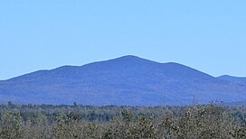
 View of Merrill Mountain from Chemin de la Rivière-Bergeron, at Piopolis, Quebec, to the west View of Merrill Mountain from Chemin de la Rivière-Bergeron, at Piopolis, Quebec, to the west | |
| Highest point | |
| Elevation | 997 m (3,271 ft) |
| Parent peak | White Mountains (Appalachian Mountains) |
| Coordinates | 45°28′27″N 70°41′32″W / 45.47417°N 70.69222°W / 45.47417; -70.69222 |
| Geography | |
| Location | Estrie Franklin County |
| Countries | Canada United States |
| Province U.S. state | Québec Maine |
| Region(s) | Region County |
Merrill Mountain (French: Montagne Merrill) is a mountain on the border between the Canadian province of Quebec, in the region of Estrie, and the U.S. state of Maine, which is part of the Appalachian Mountains; its altitude is 997 m (3,271 ft).
Geography

The mountain, located in the municipality of Frontenac, on the zec Louise-Gosford east of lac aux Araignées, is crossed by the Canada–United States border.
Toponymy
The toponym "Montagne Merrill" was formalized on November 7, 1985, by the Commission de toponymie du Québec.
See also
References
- Montagne Merrill, Commission de toponymie du Québec
- "Atlas of Canada from the Department of Natural Resources Canada – Characteristics extracted from the geographic map, database and site instrumentation". 12 September 2016. Retrieved 2021-01-06.
- "Descriptive file: Montagne Merrill". www.toponymie.gouv.qc.ca. Retrieved 2021-01-06.
This article related to a mountain, mountain range, or peak in Canada is a stub. You can help Misplaced Pages by expanding it. |
This Quebec location article is a stub. You can help Misplaced Pages by expanding it. |
This Maine state location article is a stub. You can help Misplaced Pages by expanding it. |