| Mesa River (Río Mesa) | |
|---|---|
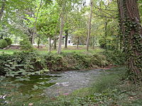
 View of the Mesa River in Jaraba View of the Mesa River in Jaraba | |
 The watershed of the Piedra within the Ebro basin The watershed of the Piedra within the Ebro basin | |
| Location | |
| Country | Spain |
| Physical characteristics | |
| Source | |
| • location | Sierra de Solorio, Guadalajara Province Castile-La Mancha |
| • elevation | 1,272 m (4,173 ft) |
| Mouth | |
| • location | Piedra River La Tranquera Dam, Aragón |
| • coordinates | 41°14′33″N 1°48′37″W / 41.24250°N 1.81028°W / 41.24250; -1.81028 |
| • elevation | 691 m (2,267 ft) |
| Length | 54.17 kilometres (33.66 mi) |
| Basin features | |
| Progression | Piedra - Jalón- Ebro - Mediterranean Sea |
| River system | Ebro |
The Mesa River (Spanish: Río Mesa) is a river in the Sierra de Solorio range area, Iberian System, Spain. It is a tributary of the Piedra River.
There are trout in the river, but the population of the endangered European freshwater crayfish in the river has practically disappeared owing to the introduction of the North American signal crayfish (Pacifastacus leniusculus).
Geography
It rises near Selas, in the province of Guadalajara, Castile-La Mancha. The Mesa has an irregular flow, due to the long dry season of the summer months, with often heavy rainfall in the spring and autumn. It receives much water at Jaraba, where there are thermal springs.
The Mesa River cuts a deep canyon, locally known as Hoces del Río Mesa (Mesa River Gorges) or Valle del Mesa (Mesa Valley).
See also
References
- Río Piedra, Entorno Natural en la Provincia de Zaragoza
- Balnearios de Jaraba Archived 2013-05-09 at the Wayback Machine
- Hoces del Río Mesa
External links
 Media related to Mesa River at Wikimedia Commons