(Redirected from Minsmere-Walberswick Heaths and Marshes )
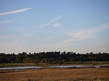
Minsmere–Walberswick Heaths and Marshes are a Special Area of Conservation and Site of Special Scientific Interest in the English county of Suffolk . The site is located on the North Sea coast between Southwold and Sizewell , extending over an area of coastline around 7 miles (11 km) in length. The site is also designated as a Special Protection Area , part of the Minsmere–Walberswick European Marine Site and contains areas designated as Ramsar sites and Natura 2000 sites. It lies within the Suffolk Coast and Heaths Area of Outstanding Natural Beauty and is made up of a "complex mosaic" of marshes, reed beds, shingle banks and lowland heath habitats.
The SSSI covers an area of 2,325.89 hectares (8.98 sq mi; 23.26 km). It is a composite site and was formed by the almagamation of the Minsmere Level, Walberswick and Brick Kiln Walks SSSI units. It extends from Hen Reedbeds and Southwold Common north of the River Blyth , through Walberswick and Dunwich to Westleton , Minsmere and Eastbridge to the north of Sizewell nuclear power stations . The area includes the Suffolk Coast National Nature Reserve sites at Hen Reedbeds, Walberswick and Dingle Marshes , the National Trust property at Dunwich Heath and the Minsmere RSPB reserve . It is a Nature Conservation Review site, Grade I, and covers two nature reserves managed by the Suffolk Wildlife Trust , Dingle Marshes and Hen Reedbeds .
Special Area of Conservation
The Special Area of Conservation is 1,265.52 hectares (4.89 sq mi; 12.66 km) in area and extends from south of the River Blyth at Walberswick to Westleton and Minsmere to the south where it includes the Minsmere RSPB reserve and marshes alongside the Minsmere River . This area includes a range of habitats, including lowland heath and shingle beach vegetation.
References
^ Minsmere to Walberswick Heaths and Marshes , Joint Nature Conservation Committee. Retrieved 2013-03-08.
^ Minsmere–Walberswick , Joint Nature Conservation Committee. Retrieved 2013-03-08.
European site conservation objectives for Minsmere to Walberswick heaths and marshes Special Area of Conservation , Natural England . Retrieved 2013-03-08.
About us , Suffolk Coast and Heaths AONB. Retrieved 2014-03-08.
Minsmere–Walberswick Heaths and Marshes , SSSI citation, Natural England . Retrieved 2014-03-08.
Magic map , Minsmere–Walberswick Heaths and Marshes SSSI, Magic. Retrieved 2014-03-08.
Ratcliffe, Derek, ed. (1977). A Nature Conservation Review . Vol. 2. Cambridge, UK: Cambridge University Press. pp. 210–211. ISBN 0521 21403 3
"Dingle Marshes" . Suffolk Wildlife Trust. Retrieved 1 May 2017."Hen Reedbeds" . Suffolk Wildlife Trust. Archived from the original on 6 September 2017. Retrieved 4 May 2017.Magic map , Minsmere to Walberswick Heaths and Marshes SAC, Magic. Retrieved 2014-03-08.
See also
Sites of Special Scientific Interest in Suffolk Biological
Abbey Wood, Flixton Alde–Ore Estuary Arger Fen Bangrove Wood, Ixworth Barking Woods Barnby Broad and Marshes Barnham Heath Berner's Heath Bixley Heath Black Ditches, Cavenham Blaxhall Heath Blo' Norton and Thelnetham Fens Bradfield Woods Breckland Farmland Breckland Forest Brent Eleigh Woods Bugg's Hole Fen, Thelnetham Burgate Wood Cavendish Woods Cavenham–Icklingham Heaths Cherry Hill and The Gallops, Barton Mills Chippenhall Green Combs Wood Cornard Mere Crag Pit, Sutton Cransford Meadow Deadman's Grave, Icklingham Deben Estuary Dew's Ponds Edwardstone Woods Elmsett Park Wood Eriswell Low Warren Fakenham Wood and Sapiston Great Grove Fox Fritillary Meadow Foxhole Heath Freston and Cutler's Woods with Holbrook Park Frithy and Chadacre Woods The Gardens, Great Ashfield Gipping Great Wood Glemsford Pits The Glen Chalk Caves, Bury St Edmunds Gosbeck Wood Gromford Meadow Groton Wood Gypsy Camp Meadows, Thrandeston Hay Wood, Whepstead Horringer Court Caves High House Meadows, Monewden Hintlesham Woods Hopton Fen How Hill Track Iken Wood Ipswich Heaths Kentwell Woods Knettishall Heath Lackford Lakes Lakenheath Poor's Fen Lakenheath Warren Landguard Common Laurel Farm Meadow Leiston - Aldeburgh Lineage Wood & Railway Track, Long Melford Lingwood Meadows Little Blakenham Pit Little Heath, Barnham London Road Industrial Estate, Brandon Lordswell Field Maidscross Hill Major Farm Meadow Metfield Meadow Mickfield Meadow Middle Wood, Offton Milden Thicks Minsmere–Walberswick Heaths and Marshes Moat Farm Meadows Monewden Meadows Nacton Meadows Newbourne Springs Newmarket Heath Norton Wood Orwell Estuary Over and Lawn Woods Pakefield to Easton Bavents Pakenham Meadows Pashford Poor's Fen, Lakenheath Potton Hall Fields, Westleton RAF Lakenheath Redgrave and Lopham Fens Rex Graham Reserve Riverside House Meadow Sandlings Forest Sinks Valley, Kesgrave Sizewell Marshes Snape Warren Sotterley Park Sprat's Water and Marshes, Carlton Colville Stallode Wash, Lakenheath Stanton Woods Staverton Park and The Thicks, Wantisden Stour Estuary Sutton and Hollesley Heaths Thetford Heaths Thorpe Morieux Woods Titsal Wood, Shadingfield Trundley and Wadgell's Wood, Great Thurlow Tunstall Common Wangford Warren and Carr Weather and Horn Heaths, Eriswell West Stow Heath Westhall Wood and Meadow Weston Fen Wilde Street Meadow Wortham Ling Geological
Alde-Ore Estuary Aldeburgh Brick Pit Aldeburgh Hall Pit Bawdsey Cliff Bobbitshole, Belstead Breckland Forest Buckanay Farm Pit, Alderton Chillesford Church Pit Corton Cliffs Crag Farm Pit, Sudbourne Crag Pit, Aldeburgh Creeting St Mary Pits Ferry Cliff, Sutton Flixton Quarry Gedgrave Hall Pit Great Blakenham Pit Hascot Hill Pit Holton Pit Hoxne Brick Pit Neutral Farm Pit, Butley Pakefield to Easton Bavents Ramsholt Cliff Red House Farm Pit Red Lodge Heath Richmond Farm Pit, Gedgrave Rockhall Wood Pit, Sutton Round Hill Pit, Aldeburgh Sandy Lane Pit, Barham Stoke Tunnel Cutting, Ipswich Stour Estuary Sudbourne Park Pit Valley Farm Pit, Sudbourne Waldringfield Pit
Categories :
Text is available under the Creative Commons Attribution-ShareAlike License. Additional terms may apply.
**DISCLAIMER** We are not affiliated with Wikipedia, and Cloudflare.
The information presented on this site is for general informational purposes only and does not constitute medical advice.
You should always have a personal consultation with a healthcare professional before making changes to your diet, medication, or exercise routine.
AI helps with the correspondence in our chat.
We participate in an affiliate program. If you buy something through a link, we may earn a commission 💕
↑
 Dingle Marshes, part of the Minsmere–Walberswick Heaths and Marshes SSSI