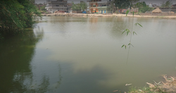
Village in Bihar, India
| Mocharim (Mucalinda) | |
|---|---|
| Village | |
 Muchalinda lake Muchalinda lake | |
 | |
| Coordinates: 24°40′50.0″N 84°59′32.0″E / 24.680556°N 84.992222°E / 24.680556; 84.992222 | |
| Country | |
| State | |
| District | Gaya |
| Municipal | Bodhgaya Nagar Parishad |
| Area | |
| • Land | 11.64 km (4.49 sq mi) |
| Elevation | 34 m (111 ft) |
| Population | |
| • Total | 9,808 |
| Languages | |
| • Official | Magahi, Hindi |
| Time zone | UTC+5:30 (IST) |
| PIN | 824231 |
Mocharim (ancient name Mucalinda) situated in the Gaya district, state of Bihar, India, nearly 1 kilometre (0.62 mi) south of the Mahabodhi Temple at Bodhgaya. It lies at the western bank of the river Niranjana (Phalgu). It is named after the naga Mucalinda or Muchalinda or Mucilinda, who is said to have protected Buddha from a great rainstorm when he was meditating. The village is home to Muchlind, an ancient pond where Buddha supposedly spent six weeks after attaining enlightenment.
References
- "Google Maps".
- "Census of India 2011: Bihar" (PDF). Census of India.
- "Locate Post Office". Department of Posts.
- ^ "Pond plan for Buddha circuit". The Telegraph. 29 October 2017.
External links
- Mocharim at deepawali night (Facebook)
- mocharim village group (Facebook)