| Mons Mouton | |
|---|---|
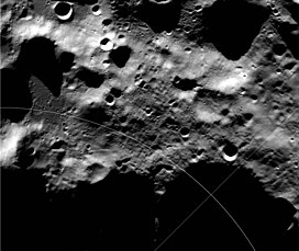
 LRO Wide Angle Camera mosaic LRO Wide Angle Camera mosaic | |
| Highest point | |
| Listing | Lunar mountains |
| Coordinates | 84°36′S 31°00′W / 84.6°S 31.0°W / -84.6; -31.0 |
| Naming | |
| Etymology | Named for Melba Roy Mouton |
| English translation | Mouton Mountain |
| Language of name | Latin |
| Geography | |
| Location | the Moon |

Mons Mouton is the Moon's tallest mountain that has been officially named. The base to peak height of this flat-topped mountain is 6 km per altimetry data from the Lunar Reconnaissance Orbiter. It lies between the craters Nobile and Malapert, within 6° of the lunar South Pole on the Moon's near-side. This is a region of special interest because of the presence of Permanently Shadowed Regions (PSRs) that could be cold traps for water, together with areas of extended solar illumination in their proximity. As a result, Mons Mouton was scheduled to become the landing site of the Volatiles Investigating Polar Exploration Rover (VIPER) prior to its cancelling.
Mons Mouton is possibly a remnant of the rim of the South Pole–Aitken basin - one of the oldest, largest and deepest impact craters in the Solar System. There are taller mountains than Mons Mouton on the Moon's far-side which are also likely part of this basin's rings, but they are as yet unnamed.
Mons Mouton was previously sometimes referred to as Leibnitz Beta, but was named on May 13, 2022, after the American mathematician Melba Roy Mouton.

References
- ^ The Moon's Highs and Lows
- ^ SVS, NASA's (2023-05-30). "SVS: Mons Mouton, a Newly Named Lunar Mountain". SVS. Retrieved 2023-09-24.
- Wright, Ernie; Ladd, David; Colaprete, Anthony; Ladd, David (2021-09-20). "NASA Scientific Visualization Studio". SVS. Retrieved 2023-10-27.
- Mons Mouton Gazetteer of Planetary Nomenclature, International Astronomical Union (IAU) Working Group for Planetary System Nomenclature (WGPSN)
External links
 Media related to Mons Mouton at Wikimedia Commons
This article related to the Moon is a stub. You can help Misplaced Pages by expanding it. |