| Mount Louise | |
|---|---|
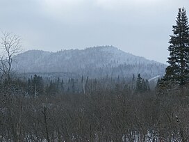
 Mont Louise near Saints-Martyrs-Canadiens. Mont Louise near Saints-Martyrs-Canadiens. | |
| Highest point | |
| Peak | 475 metres (1,558 ft) |
| Parent peak | Notre Dame Mountains (Appalachian Mountains) |
| Coordinates | 45°51′15″N 71°30′05″W / 45.85417°N 71.50139°W / 45.85417; -71.50139 |
| Geography | |
| Location | Estrie |
| Country | Canada |
| Province | Québec |
| Region | Region |
Mount Louise is part of the low plateaus of the Appalachian Mountains very close to the municipality of Saints-Martyrs-Canadiens; it is located in the Arthabaska Regional County Municipality, in the administrative region of Centre-du-Québec in Quebec, in Canada. It rises to 475 metres (1,558 ft) above sea level.
Toponymy
The toponym "Mont Louise" was formalized on December 5, 1968 by the Commission de toponymie du Québec.
References
- Mont Louise, Commission de toponymie du Québec.
- "Descriptive file: Mont Louise". www.toponymie.gouv.qc.ca. Retrieved 2021-01-06.