| This article needs additional citations for verification. Please help improve this article by adding citations to reliable sources. Unsourced material may be challenged and removed. Find sources: "Nienstädt" – news · newspapers · books · scholar · JSTOR (November 2024) (Learn how and when to remove this message) |
| Nienstädt | |
|---|---|
| Municipality | |
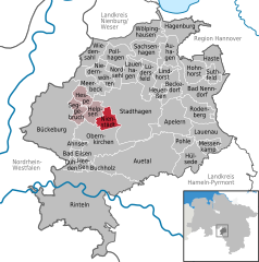
Location of Nienstädt within Schaumburg district
 | |
  | |
| Coordinates: 52°17′21″N 9°10′7″E / 52.28917°N 9.16861°E / 52.28917; 9.16861 | |
| Country | Germany |
| State | Lower Saxony |
| District | Schaumburg |
| Municipal assoc. | Nienstädt |
| Subdivisions | 4 |
| Government | |
| • Mayor | Gerhard Widdel (SPD) |
| Area | |
| • Total | 8.31 km (3.21 sq mi) |
| Elevation | 104 m (341 ft) |
| Population | |
| • Total | 4,476 |
| • Density | 540/km (1,400/sq mi) |
| Time zone | UTC+01:00 (CET) |
| • Summer (DST) | UTC+02:00 (CEST) |
| Postal codes | 31688 |
| Dialling codes | 05721, 05724 |
| Vehicle registration | SHG |
Nienstädt is a municipality in the district of Schaumburg, in Lower Saxony, Germany. It is situated approximately 4 km southwest of Stadthagen, and 17 km east of Minden.
Nienstädt is part of the Samtgemeinde ("collective municipality") Nienstädt.
Geography
Nienstädt lies on the northern slopes of the Bückeberge between Bückeburg and Stadthagen on the B 65 federal highway.
The four parishes in the municipality are Sülbeck, Liekwegen, Wackerfeld and Meinefeld. While Sülbeck and Nienstädt are bisected by the B 65, Liekwegen runs along the Bückeberg as a ribbon village. Wackerfeld and Meinefeld lie in open country north of Nienstädt.
Neighbouring communities (clockwise) are the towns of Stadthagen and Obernkirchen and the village of Helpsen.
References
- "LSN-Online Regionaldatenbank, Tabelle A100001G: Fortschreibung des Bevölkerungsstandes, Stand 31. Dezember 2022" (in German). Landesamt für Statistik Niedersachsen.
This Schaumburg location article is a stub. You can help Misplaced Pages by expanding it. |