Place in Region I, Philippines
| One Pangasinan Alliance | |
|---|---|
| Country | |
| Region | Region I |
| Island | Luzon |
| Province | Pangasinan |
| Cities | |
| Legislative Districts | 1st District of Pangasinan |
| Government | |
| • Type | Economic Alliance |
| Area | |
| • Total | 1,759 km (679 sq mi) |
| Population | |
| • Total | 379,637 |
| Time zone | UTC+8 (Philippine Standard Time) |
One Pangasinan Alliance or OPAL (DMA) is an economic alliance of six towns and one city of western Pangasinan, representing the 1st District of Pangasinan. It is composed of Alaminos, Agno, Anda, Bani, Bolinao, Burgos, Dasol, Infanta, Mabini & Sual
According to the 2007 Philippine census, OPAL is home to 379,637 people and a land area of 1,759.
Geography
Components
| LGU | Income Class | District | Population (2007) | Area (km²) |
|---|---|---|---|---|
| Alaminos | 4th class, component city | 1st | 79,788 | 164 |
| Agno | 3rd Class | 1st | 26,023 | 170 |
| Anda | 3rd Class | 1st | 34,398 | 75 |
| Bani | 2nd Class | 1st | 45,652 | 180 |
| Burgos | 4th Class | 1st | 20,187 | 131 |
| Dasol | 3rd Class | 1st | 27,027 | 167 |
| Infanta | 3rd Class | 1st | 23,731 | 254 |
| Mabini | 3rd Class | 1st | 23,338 | 291 |
| Sual | 1st Class | 1st | 29,925 | 130 |
Physical
OPAL is bounded by the 2nd District of Pangasinan to the South East, Lingayen Gulf to the North and North East, South China Sea facing West and Zambales on the South.
Economy

OPAL's economic drivers are Aquaculture, Tourism, Farming and Mineral extraction.
Energy
The 1200 megawatt Sual Coal-Fired Power Plant is located in the town of Sual.
Marine
Fish pens and fishponds dot the coastline of OPAL.
Agriculture
The major crops in are rice, mangoes, and corn.
Tourist attractions
- Cape Bolinao Beach in Bolinao
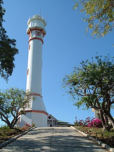
Cape Bolinao Lighthouse - Tambobong White Beach in Dasol
- Caves of Dasol
- Tondol Beach in Anda
- Cacupangan Cave System (Bintanilya, Binmatya, Villacorta Caves) in Brgys Tagudin & Villacorta, Mabini
- Sto. Rosario Cave System (Tubo-Tubo, Bual, Cabalyoriza Caves) in Brgys San Pedro & Barlo, Mabini
- Caves in Brgy. De Guzman, Mabini
- Balincaguin River in Mabini
- Sawang Falls in Brgy. Villcorta, Mabini
- Nalsoc Cave System (Mel-let, Abot Aso Caves) in Brgy. Colayo, Bani
- Bolinao Museum in Bolinao
- Hundred Islands Marine Sanctuary in Alaminos
- Oceanographic Marine Laboratory in Alaminos
- Hundred Islands National Park of Alaminos
- Umbrella Rocks of Agno
- Viewdeck in Suasalito, Sual, Pangasinan
- Dumaloy Cave & Sinkhole in Bolinao
Investment
| This section is empty. You can help by adding to it. (January 2011) |
See also
References
- "List of Cities". Retrieved July 7, 2010.
- Lilia M. Micua (June 30, 2009). "OPAL to be institutionalized as economic alliance in western Pangasinan". Retrieved May 1, 2018.
- "NSCB - ActiveStats - PSGC Interactive - Municipality: CITY OF ALAMINOS". Archived from the original on November 14, 2010. Retrieved October 13, 2010.
- http://www.alaminoscity.gov.ph/news/newsdetails.aspx?newsid=518
- http://www.hundredislands.ph/news/ndetail.asp?ID=465
- http://sundaypunch.prepys.com/archives/2009/06/08/opal-tapping-river-for-potable-water/
- "Alliance of Pangasinan LGUs receives CIDA funding". June 8, 2009. Retrieved May 1, 2018.
External links
- Official Website of National Economic and Development Authority
- Official Website of LGU-Mabini
- Balincaguin Conservancy Grotto
| Lingayen (capital) San Carlos City (largest city) | |
| Municipalities |
|
| Component cities | |
| Independent component city |
|
| Barangays | See: List of barangays in Pangasinan |
