| Ortaköy District | |
|---|---|
| District | |
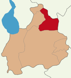
 Map showing Ortaköy District in Aksaray Province Map showing Ortaköy District in Aksaray Province | |
  | |
| Coordinates: 38°44′N 34°02′E / 38.733°N 34.033°E / 38.733; 34.033 | |
| Country | Turkey |
| Province | Aksaray |
| Seat | Ortaköy |
| Government | |
| • Kaymakam | Ahmet Karatepe |
| Area | 727 km (281 sq mi) |
| Population | 32,130 |
| • Density | 44/km (110/sq mi) |
| Time zone | UTC+3 (TRT) |
| Website | www |
Ortaköy District is a district of Aksaray Province of Turkey. Its seat is the town Ortaköy. Its area is 727 km, and its population is 32,130 (2021). It is a rural district centred on the small, quiet town of Ortaköy.
Composition
There is one municipality in Ortaköy District:
There are 30 villages in Ortaköy District:
- Akpınar
- Bozkır
- Camuzluk
- Çatin
- Ceceli
- Çiftevi
- Cumali
- Devedamı
- Durhasanlı
- Gökkaya
- Gökler
- Hacıibrahimuşağı
- Hacımahmutuşağı
- Harmandalı
- Hıdırlı
- Hocabeyli
- Karapınar
- Kümbet
- Namlıkışla
- Oğuzlar
- Ozancık
- Pınarbaşı
- Pirli
- Reşadiye
- Salarıalaca
- Salarıgödeler
- Sarıkaraman
- Satansarı
- Seksenuşağı
- Yıldırımlar
References
- ^ İlçe Belediyesi, Turkey Civil Administration Departments Inventory. Retrieved 12 January 2023.
- "İl ve İlçe Yüz ölçümleri". General Directorate of Mapping. Retrieved 12 January 2023.
- "Address-based population registration system (ADNKS) results dated 31 December 2021" (XLS) (in Turkish). TÜİK. Retrieved 12 January 2023.
- Köy, Turkey Civil Administration Departments Inventory. Retrieved 15 January 2023.
| Ortaköy District, Aksaray in Aksaray Province of Turkey | ||
|---|---|---|
| Districts |  | |
| Metropolitan municipalities are bolded. | ||
| Municipalities | |
|---|---|
| Villages | |
This geographical article about a location in Aksaray Province, Turkey is a stub. You can help Misplaced Pages by expanding it. |
