You can help expand this article with text translated from the corresponding article in German. (September 2011) Click for important translation instructions.
|
| Osterbek Osterbekkanal | |
|---|---|
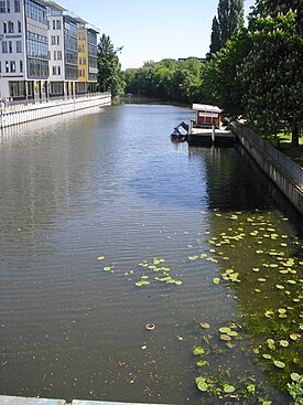
 Osterbekkanal in Hamburg Osterbekkanal in Hamburg | |
| Location | |
| Country | Germany |
| State | Hamburg |
| Physical characteristics | |
| Source | |
| • location | Farmsen-Berne, Hamburg |
| • coordinates | 53°37′17″N 10°6′43″E / 53.62139°N 10.11194°E / 53.62139; 10.11194 |
| • elevation | 20 m (66 ft) |
| Mouth | Alster (Außenalster) |
| • location | Winterhude, Hamburg |
| • coordinates | 53°34′35″N 10°0′21″E / 53.57639°N 10.00583°E / 53.57639; 10.00583 |
| • elevation | 6 m (20 ft) |
| Length | 8.5 km (5.3 mi) |
| Basin features | |
| Tributaries | |
| • left | Hopfengraben |
| • right | Seebek |
| Progression | Alster→ Elbe→ North Sea |
Osterbek is a river of Hamburg, Germany. The Osterbek has its source at Farmsen-Berne in the Hamburg borough of Wandsbek. After crossing into the borough of Hamburg-Nord, the Osterbek becomes navigable as Osterbekkanal. It joins the Alster at Außenalster, between the districts Winterhude and Uhlenhorst.
See also
References
- "Umsetzung der EG-Wasserrahmenrichtlinie (WRRL)". Freie und Hansestadt Hamburg (FHH). 20 September 2004. Retrieved 2 January 2019.
- Gesamtliste der Fließgewässer im Elbeeinzugsgebiet, Flussgebietsgemeinschaft Elbe (FGG), Magdeburg, 2010
This Hamburg location article is a stub. You can help Misplaced Pages by expanding it. |
This article related to a river in Germany is a stub. You can help Misplaced Pages by expanding it. |