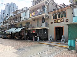
| Pan Chung Chinese: 泮涌 | |
|---|---|
| Village | |
 Entrance gate of Pan Chung. Entrance gate of Pan Chung. | |
 | |
| Coordinates: 22°26′43″N 114°09′57″E / 22.445308°N 114.165748°E / 22.445308; 114.165748 | |
| Country | People's Republic of China |
| Special administrative region | Hong Kong |
| District | Tai Po District |
| Time zone | UTC+8:00 (HKT) |
Pan Chung (Chinese: 泮涌) is a walled village in Tai Po District, Hong Kong.
Administration


Pan Chung and neighboring Pan Chung San Tsuen (泮涌新村; 'Pan Chung New Village') are recognized villages under the New Territories Small House Policy.
It is one of the villages represented within the Tai Po Rural Committee. For electoral purposes, Pan Chung is part of the San Fu constituency, which was formerly represented by Max Wu Yiu-cheong until May 2021.
See also
References
- "List of Recognized Villages under the New Territories Small House Policy" (PDF). Lands Department. September 2009.
- "Recommended District Council Constituency Areas (Tai Po District)" (PDF). Electoral Affairs Commission. Retrieved 29 November 2021.
- "Tai Po District Council - Tai Po DC Members". District Council. Retrieved 29 November 2021.
External links
- Delineation of area of existing village Pan Chung (Tai Po) for election of resident representative (2019 to 2022)
- Delineation of area of existing village Pan Chung San Tsuen (Tai Po) for election of resident representative (2019 to 2022)
- Antiquities Advisory Board. Historic Building Appraisal. Shrine, Pan Chung, Tai Po Pictures
- Antiquities Advisory Board. Historic Building Appraisal. Mak Ancestral Hall, No. 16 Pan Chung, Tai Po Pictures
This Hong Kong location article is a stub. You can help Misplaced Pages by expanding it. |