| Payachata | |
|---|---|
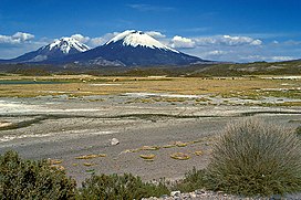
 The Pomerape (left) and Parinacota (right) volcanoes The Pomerape (left) and Parinacota (right) volcanoes | |
| Highest point | |
| Elevation | Parinacota: 6,348 m (20,827 ft); Pomerape: 6,282 m (20,610 ft) |
| Coordinates | 18°9.799′S 69°8.550′W / 18.163317°S 69.142500°W / -18.163317; -69.142500 |
| Geography | |
| Location | Bolivia-Chile |
| Parent range | Andes |
| Geology | |
| Mountain type | Stratovolcano |
| Last eruption | 290 AD ± 300 years (Parinacota) |
Payachata or Paya Chata (Aymara pä, paya two, Pukina chata mountain, "two mountains") is a north–south trending complex of potentially active volcanos on the border of Bolivia and Chile, directly north of Chungará Lake. The complex contains two peaks, Pomerape to the north and Parinacota to the south. On the Bolivian side the volcanoes are located in the Oruro Department, Sajama Province, Curahuara de Carangas Municipality, and on the Chilean side they lie in the Arica y Parinacota Region, Parinacota Province.
According to helium surface dating, Parinacota has erupted within the last 2000 years, while Pomerape is Pleistocene.
See also
References
- *Vocabulario de la Lengua Aymara, a historical dictionary by Ludovico Bertonio (1612) (Transcription): Paya - Vide supra: pä. Que significa dos solamente, ...
- Teofilo Laime Ajacopa, Lengua Pukina en Jesús de Machaca, referring to Alfredo Torero ("Reflexión acerca del pukina escrito por Alfredo Torero ... Pukina <Chata> - Castellano Cerro - Palabras relacionadas en aymara Qullu") (English: mountain).
- ine.gob.bo Archived 2014-11-11 at the Wayback Machine Population data and map of the Curahuara de Carangas Municipality
External links
18°09′S 69°08′W / 18.150°S 69.133°W / -18.150; -69.133
This Arica y Parinacota Region location article is a stub. You can help Misplaced Pages by expanding it. |
This Oruro Department location article is a stub. You can help Misplaced Pages by expanding it. |