| Pena Verde | |
|---|---|
| Civil parish | |
 | |
| Coordinates: 40°43′41″N 7°30′18″W / 40.728°N 7.505°W / 40.728; -7.505 | |
| Country | |
| Region | Centro |
| Intermunic. comm. | Viseu Dão Lafões |
| District | Guarda |
| Municipality | Aguiar da Beira |
| Area | |
| • Total | 29.40 km (11.35 sq mi) |
| Population | |
| • Total | 813 |
| • Density | 28/km (72/sq mi) |
| Time zone | UTC+00:00 (WET) |
| • Summer (DST) | UTC+01:00 (WEST) |
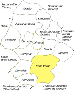
Pena Verde is a freguesia in Aguiar da Beira Municipality, Guarda District, Portugal. The population in 2011 was 813, in an area of 29.40 km. The Pillory of Pena Verde is located in this freguesia.
Demography
References
- "Freguesia de Penaverde". cm-aguiardabeira.pt (in Portuguese). Município de Aguiar da Beira. Retrieved 5 February 2014.
- Instituto Nacional de Estatística
- "Áreas das freguesias, concelhos, distritos e país". Archived from the original on 2018-11-05. Retrieved 2018-11-05.
| Parishes of Aguiar da Beira Municipality | |
|---|---|
This Guarda location article is a stub. You can help Misplaced Pages by expanding it. |
