| Pikchu | |
|---|---|
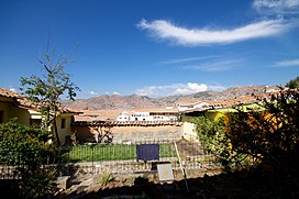
 Antennas on top of Pikchu (on the right) Antennas on top of Pikchu (on the right) | |
| Highest point | |
| Elevation | 3,800 m (12,500 ft) |
| Coordinates | 13°30′50″S 71°59′45″W / 13.51389°S 71.99583°W / -13.51389; -71.99583 |
| Naming | |
| Language of name | Quechua |
| Geography | |
 | |
| Location | Peru, Cusco Region |
| Parent range | Andes |
Pikchu (Quechua for pyramid/mountain or prominence with a broad base which ends in sharp peaks, Hispanicized spelling Picchu) is a mountain in the Andes of Peru west of the city of Cusco, about 3,800 metres (12,467 ft) high. It is located in the Cusco Region, Cusco Province, Cusco District.
Presently there are numerous microwave antennas on top of the mountain.
See also
References
- ^ qosqo.com "Qosqo Inkas' Sacred Capital"
- Diccionario Quechua - Español - Quechua, Academía Mayor de la Lengua Quechua, Gobierno Regional Cusco, Cusco 2005 (Quechua-Spanish dictionary)
- PNUD-INDECI, Estudio del Mapa de Peligros de la Ciudad del Cusco, Proyecto: Ciudades Sostenibles. Cusco 2004 (in Spanish)
- Mónica Gudemos, Capac, Camac, Yacana. El Capac Raymi y la música como emblema de poder, Anales del Museo de America 13 (2005), p. 14, Universidad Nacional de Córdoba, Argentina.
- escale.minedu.gob.pe - UGEL map of the Cusco Province (Cusco Region) (unnamed, near "Union Callanca")
This Peru mountain, mountain range, or peak related article is a stub. You can help Misplaced Pages by expanding it. |