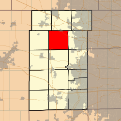
Township in Illinois, United States
| Plato Township | |
|---|---|
| Township | |
 Location in Kane County Location in Kane County | |
 Kane County's location in Illinois Kane County's location in Illinois | |
| Coordinates: 42°01′34″N 88°25′52″W / 42.02611°N 88.43111°W / 42.02611; -88.43111 | |
| Country | |
| State | |
| County | Kane |
| Established | November 6, 1849 |
| Area | |
| • Total | 33.51 sq mi (86.8 km) |
| • Land | 33.51 sq mi (86.8 km) |
| • Water | 0 sq mi (0 km) 0% |
| Elevation | 922 ft (281 m) |
| Population | |
| • Estimate | 6,356 |
| • Density | 184/sq mi (71/km) |
| Time zone | UTC-6 (CST) |
| • Summer (DST) | UTC-5 (CDT) |
| ZIP codes | 60123, 60140, 60151, 60175 |
| FIPS code | 17-089-60365 |
Plato Township is one of sixteen townships in Kane County, Illinois, USA. As of the 2010 census, its population was 6,166 and it contained 2,182 housing units. It was originally named Homer Township; the name was changed to Plato on July 2, 1850.
Geography
According to the 2010 census, the township has a total area of 33.51 square miles (86.8 km), all land.
Cities, towns, villages
- Campton Hills (partial)
- Elgin (partial)
- Pingree Grove (partial)
Unincorporated towns
- Bowes at 42°00′29″N 88°23′27″W / 42.0080822°N 88.3909136°W / 42.0080822; -88.3909136
- Bowes Bend at 42°00′39″N 88°24′53″W / 42.0108598°N 88.4148031°W / 42.0108598; -88.4148031
- Chippewa at 42°01′17″N 88°24′54″W / 42.0214153°N 88.4150813°W / 42.0214153; -88.4150813
- Hidden Lakes at 42°01′32″N 88°24′47″W / 42.0255819°N 88.4131369°W / 42.0255819; -88.4131369
- McQueen at 42°03′43″N 88°23′05″W / 42.0619702°N 88.3848039°W / 42.0619702; -88.3848039
- North Plato at 42°03′18″N 88°27′51″W / 42.0550257°N 88.4642502°W / 42.0550257; -88.4642502
- Plato Center at 42°01′36″N 88°25′48″W / 42.0266929°N 88.4300818°W / 42.0266929; -88.4300818
- Plato Corners at 41°59′13″N 88°24′18″W / 41.9869713°N 88.40508°W / 41.9869713; -88.40508
- Silent Meadow at 42°00′42″N 88°25′25″W / 42.0116932°N 88.4236923°W / 42.0116932; -88.4236923
- Tamara Heights at 42°00′10″N 88°25′52″W / 42.0028044°N 88.4311922°W / 42.0028044; -88.4311922
- Udina (west half) at 42°02′36″N 88°22′34″W / 42.043331°N 88.376114°W / 42.043331; -88.376114
(This list is based on USGS data and may include former settlements.)
Airports and landing strips
- Olson Airport
Cemeteries
The township contains these five cemeteries: Plato Center, L R Baker, North Plato, Udina and Washington Memorial.
Major highways
Demographics
| Census | Pop. | Note | %± |
|---|---|---|---|
| 2016 (est.) | 6,356 | ||
| U.S. Decennial Census | |||
School districts
- Central Community Unit School District 301
- Community Unit School District 300
- School District U-46
- St. Charles Community Unit School District 303
Political districts
- Illinois's 14th congressional district
- State House District 49
- State Senate District 25
References
- "Plato Township, Kane County, Illinois". Geographic Names Information System. United States Geological Survey, United States Department of the Interior. Retrieved June 26, 2010.
- United States Census Bureau 2009 TIGER/Line Shapefiles
- United States National Atlas
- ^ "Population and Housing Unit Estimates". Retrieved June 9, 2017.
- ^ "Population, Housing Units, Area, and Density: 2010 - County -- County Subdivision and Place -- 2010 Census Summary File 1". United States Census. Archived from the original on February 12, 2020. Retrieved May 28, 2013.
- "Census of Population and Housing". Census.gov. Retrieved June 4, 2016.
External links
| Places adjacent to Plato Township, Illinois | ||||||||||||||||
|---|---|---|---|---|---|---|---|---|---|---|---|---|---|---|---|---|
| ||||||||||||||||
| Municipalities and communities of Kane County, Illinois, United States | ||
|---|---|---|
| County seat: Geneva | ||
| Cities | ||
| Villages | ||
| Townships | ||
| CDP | ||
| Other unincorporated communities | ||
| Footnotes | ‡This populated place also has portions in an adjacent county or counties | |
