| This article needs additional citations for verification. Please help improve this article by adding citations to reliable sources. Unsourced material may be challenged and removed. Find sources: "Polmorla" – news · newspapers · books · scholar · JSTOR (March 2008) (Learn how and when to remove this message) |
| Polmorla | |
|---|---|
 Polmorla Polmorla | |
 | |
| OS grid reference | SW983715 |
| Civil parish |
|
| Shire county | |
| Region | |
| Country | England |
| Sovereign state | United Kingdom |
| Post town | Wadebridge |
| Postcode district | PL27 |
| Dialling code | 01208 |
| Police | Devon and Cornwall |
| Fire | Cornwall |
| Ambulance | South Western |
| UK Parliament |
|
| 50°30′29″N 4°50′38″W / 50.508°N 4.844°W / 50.508; -4.844 | |
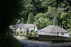
Polmorla is a hamlet just southwest of Wadebridge, Cornwall, England, United Kingdom, map reference SW983715. The Polmorla brook is a tributary of the River Camel, and rises on St Breock Downs.
References
- Ordnance Survey 1:50 000 First Series; Newquay and Bodmin, sheet 200. 1974
External links
![]() Media related to Polmorla at Wikimedia Commons
Media related to Polmorla at Wikimedia Commons
This article about a location in the former district of North Cornwall, England is a stub. You can help Misplaced Pages by expanding it. |