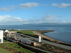
Village in Ulster, Ireland
| Quigley's Point Rinn Uí Choigligh | |
|---|---|
| Village | |
 Vance's Point, Quigley's Point Vance's Point, Quigley's Point | |
 | |
| Coordinates: 55°07′30″N 7°11′50″W / 55.1249°N 7.1971°W / 55.1249; -7.1971 | |
| Country | Ireland |
| Province | Ulster |
| County | County Donegal |
| Population | 213 |
| Time zone | UTC+0 (WET) |
| • Summer (DST) | UTC-1 (IST (WEST)) |
| Irish Grid Reference | C513310 |
Quigley's Point (Irish: Rinn Uí Choigligh) is a village in County Donegal, Ireland. Located on the eastern shores of Inishowen and overlooking Lough Foyle, the village is sometimes known locally as "Carrowkeel" (or "Carowkeel") as it is in a townland of that name. To the south is the city of Derry and to the north lie the villages of Moville and Greencastle. A car ferry links Greencastle with Magilligan during the summer. The river Cabry, which flows through the area, is spanned by a late-18th century bridge at Quigley's Point.
Evidence of ancient settlement in the area includes a standing stone site in Cabry townland, and a reputed former cromlech site (since removed) in Carrowkeel townland.
The Presbyterian Church in Ireland has a church at Greenbank near the village. Greenbank Presbyterian Church was built in 1862 in a "Gothic influenced" style. The nearby Presbyterian church hall, which was gutted by fire following an apparent arson attack in 2003, was subsequently restored.
Quigley's Point had a population of 213 people at the time of the 2022 census, down slightly from 227 in the 2011 census.
See also
References
- "Census Interactive Map - Towns: Quigleys Point - Population Snapshot". visual.cso.ie. Central Statistics Office (Ireland). Retrieved 25 August 2024.
- "Rinn Uí Choigligh / Quigley's Point". logainm.ie. Placenames Database of Ireland. Retrieved 29 October 2021.
- "Carrowkeel Townland, Co. Donegal". townlands.ie. Retrieved 29 October 2021.
- "Donegal bridges gaps after 'all hands on deck' flood response". irishtimes.com. Irish Times. 2 September 2017. Retrieved 29 October 2021.
- "Carrowkeel, Carrowkeel (Carrowkeel), Quigley's Point, Donegal". buildingsofireland.ie. National Inventory of Architectural Heritage. Retrieved 29 October 2021.
Triple-arch road bridge spanning the Cabry River, built c. 1780
- Cody, Eamon, ed. (2002). Survey of the Megalithic Tombs of Ireland. Volume VI, County Donegal. Dublin: Government Stationery Office.
Megalithic tomb - unclassified Carrowkeel This feature is named 'Cromlech' on the original OS 6-inch map (1833-4). There are no visible remains at the site Whatever the nature of this feature, it had apparently been removed by 1848, as it is named 'Site of Cromlech' on the OS 6-inch map of that date
- "Greenbank Presbyterian Church, Carrowkeel, Tromaty, Quigley's Point, Donegal". buildingsofireland.ie. National Inventory of Architectural Heritage. Retrieved 29 October 2021.
- "Police suspect gang of arson attacks". irishtimes.com. Irish Times. 15 July 2003. Retrieved 29 October 2021.
Greenbank Presbyterian church hall at Quigleys Point, Co Donegal, was destroyed in an early morning fire yesterday. The building, which is over 150 years old, was used as a social, community and badminton hall
- "Arson attacks on church and masonic halls 'linked'". independent.ie. Independent News & Media. 15 July 2003. Retrieved 29 October 2021.
- "Greenbank Presbyterian Church". inishowen4pc.com. Retrieved 29 October 2021.
The church hall was subject to an arson attack in 2003 but Greenbank rose up from the ashes with a wonderful new hall
- "Quigleys Point (Ireland) Census Town". City Population. Retrieved 25 August 2024.
