| Ramu | |
|---|---|
| Upazila | |
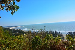
 Beach in Himchari National Park Beach in Himchari National Park | |
 | |
| Coordinates: 21°27.5′N 92°6′E / 21.4583°N 92.100°E / 21.4583; 92.100 | |
| Country | |
| Division | Chittagong |
| District | Cox's Bazar |
| Area | |
| • Total | 391.71 km (151.24 sq mi) |
| Population | |
| • Total | 344,545 |
| • Density | 880/km (2,300/sq mi) |
| Time zone | UTC+6 (BST) |
| Postal code | 4730 |
| Area code | 03425 |
| Website | ramu |
Ramu (Bengali: রামু) is an upazila of Cox's Bazar District in the Division of Chittagong, Bangladesh.
Geography
Ramu is located at 21°27′30″N 92°06′00″E / 21.4583°N 92.1000°E / 21.4583; 92.1000. It has 47,904 households and an area of 391.71 km.
Demographics
| Religions in Ramu Upazila (2022) | ||||
|---|---|---|---|---|
| Religion | Percent | |||
| Islam | 93.91% | |||
| Hinduism | 3.09% | |||
| Buddhism | 2.95% | |||
| Other or not stated | 0.05% | |||
As of the 2011 Census of Bangladesh, Ramu upazila had 47,904 households and a population of 266,640. 78,531 (29.45%) were under 10 years of age. Ramu had an average literacy rate of 36.58%, compared to the national average of 51.8%, and a sex ratio of 975 females per 1000 males. 42,072 (15.78%) of the population lived in urban areas.
As of the 1991 Bangladesh census, Ramu has a population of 167480. Males constitute 51.41% of the population, and females 48.59%. This Upazila's eighteen up population is 74742. Ramu has an average literacy rate among town people is 34%., and the national average of 32.4% literate. Ramu thana was transformed into an upazila in 1983. It consists of 9 union parishads, 39 mouzas and 102 villages.
Administration
Ramu Upazila is divided into 11 union parishads: Chakmarkul, Dakshin Mithachhari, Eidghar, Fotekharkul, Garjoniya, Jouarianala, Kacchapia, Kawarkhop, Khuniapalong, Rajarkul, and Rashidnagar. The union parishads are subdivided into 39 mauzas and 102 villages. the union parishad
References
- National Report (PDF). Population and Housing Census 2022. Vol. 1. Dhaka: Bangladesh Bureau of Statistics. November 2023. p. 397. ISBN 978-9844752016.
- "Bangladesh Postal Code". Dhaka: Bangladesh Postal Department under the Department of Posts and Telecommunications of the Ministry of Posts, Telecommunications and Information Technology of the People's Republic of Bangladesh. 20 October 2024.
- "Bangladesh Area Code". China: Chahaoba.com. 18 October 2024.
- Chowdhury, Muhammad Tawhid Hossain (2012). "Ramu Upazila". In Islam, Sirajul; Jamal, Ahmed A. (eds.). Banglapedia: National Encyclopedia of Bangladesh (Second ed.). Asiatic Society of Bangladesh.
- Population and Housing Census 2022 - District Report: Cox’s Bazar (PDF). District Series. Dhaka: Bangladesh Bureau of Statistics. June 2024. ISBN 978-984-475-266-5.
- "Bangladesh Population and Housing Census 2011 Zila Report – Cox's Bazar" (PDF). bbs.gov.bd. Bangladesh Bureau of Statistics.
- "Community Tables: Cox's Bazar district" (PDF). bbs.gov.bd. Bangladesh Bureau of Statistics. 2011. p. 103.
- "Table S04: Selected Statistics By Thana, 1991 (Enumerated)". Bangladesh Government. Archived from the original on 27 March 2005. Retrieved 25 August 2018.
- "District Statistics 2011: Cox's Bazar" (PDF). Bangladesh Bureau of Statistics. Archived from the original (PDF) on 13 November 2014. Retrieved 14 July 2014.
| Cox's Bazar District | ||
|---|---|---|
| Capital: Cox's Bazar | ||
| Upazilas | ||
| Constituencies | ||
| Attractions and sites |
| |
| History | ||
| Inhabited areas | ||
| Educational institutions | ||
| Organisations | ||
| Transport | ||
