| This article relies largely or entirely on a single source. Relevant discussion may be found on the talk page. Please help improve this article by introducing citations to additional sources. Find sources: "Rastinėnai" – news · newspapers · books · scholar · JSTOR (October 2019) |
| Rastinėnai | |
|---|---|
| Village | |
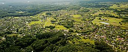
 Rastinėnai village as seen from a plane. Rastinėnai village as seen from a plane. | |
 | |
| Coordinates: 54°45′50″N 25°02′38″E / 54.76389°N 25.04389°E / 54.76389; 25.04389 | |
| Country | |
| County | |
| Municipality | Vilnius district municipality |
| Eldership | Sudervė eldership |
| Population | |
| • Total | 556 |
| Time zone | UTC+2 (EET) |
| • Summer (DST) | UTC+3 (EEST) |
Rastinėnai is a village in Vilnius district municipality, Lithuania, a suburb of Vilnius. Formerly famous as collective gardening settlement during Lithuanian SSR times, after privatization and transformation into the suburban settlement, it had population of 556 as according to the 2011 census, up from 95 in 1970 and 321 in 2001.
References
- "2011 census". Statistikos Departamentas (Lithuania). Retrieved August 29, 2019.
This Vilnius district municipality, Vilnius County, Lithuania location article is a stub. You can help Misplaced Pages by expanding it. |
