| This article needs additional citations for verification. Please help improve this article by adding citations to reliable sources. Unsourced material may be challenged and removed. Find sources: "Ratnagiri Fort, Maharashtra" – news · newspapers · books · scholar · JSTOR (December 2018) (Learn how and when to remove this message) |
| Ratnadurg Fort | |
|---|---|
| Part of Konkan Coast | |
| Ratnagiri district, Maharashtra | |
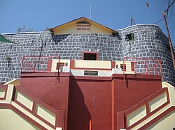
 Entrance of Ratnadurg Fort Entrance of Ratnadurg Fort | |
 | |
| Coordinates | 16°59′46.3″N 73°16′13″E / 16.996194°N 73.27028°E / 16.996194; 73.27028 |
| Type | Sea Fort |
| Height | 200 Ft. |
| Site information | |
| Owner | Government of India |
| Controlled by | Bijapur (1521–1594)
|
| Open to the public | Yes |
| Condition | Ruins |
| Site history | |
| Materials | Laterite Stone |
Ratnagiri Fort, also called Ratnadurg Fort or Bhagawati Fort, is a fort located 2 km from Ratnagiri, in Ratnagiri district, of Maharashtra. This fort is an important fort in Ratnagiri district. The fort is a main tourist attraction due to the Bhagawati Temple inside the fort.
History
This fort was built during the Bahamani period. In 1670 Maratha King Shivaji won the fort from the hands of Adil Shah of Bijapur. King Shivaji had built protecting towers on two commanding points, one at the south and the other near the old court house. The Citadel defense was improved by maratha admiral Kanhoji Angre in 1750–1755. Dhondu Bhaskar Pratinidhi did some minor repairs to the fort during Peshwa regime (1755–1818). The fort was later won by the British in 1818. The temple of Bhagavati was renovated in 1950.
How to reach
The nearest town is Ratnagiri. The fort is at walkable distance from the town. A wide road leads to the entrance gate of the fort. It takes about an hour to have a walk around the fort.
Places to see


The lighthouse is situated on one side of the fort. Inside the fort is Bhagawati temple, a pond and a well. There is a cave below the fort. The strongest of all the bastion is Rede Buruj.

16°59′46.3″N 73°16′13″E / 16.996194°N 73.27028°E / 16.996194; 73.27028
See also
- List of forts in Maharashtra
- List of forts in India
- Kanhoji Angre
- Marathi people
- Maratha Navy
- List of Maratha dynasties and states
- Maratha War of Independence
- Battles involving the Maratha Empire
- Military history of India
References
- "Ratnadurg, Sahyadri,Shivaji,Trekking,Marathi,Maharastra". Trekshitiz.com. Retrieved 19 December 2018.
- Pathak, Arunachandra S. (25 December 2006). Maharashtra State Gazetteers- Ratnagiri District. Mumbai: Government of Maharashtra. p. Places>Ratnagiri>Fort. Retrieved 13 December 2019.
- Trekshitiz. "Tringalwadi". www.trekshitiz.com. Trekshitiz. Retrieved 13 December 2019.