| Reka | |
|---|---|
 | |
 | |
| Coordinates: 46°8′17″N 14°48′16″E / 46.13806°N 14.80444°E / 46.13806; 14.80444 | |
| Country | |
| Traditional region | Upper Carniola |
| Statistical region | Central Slovenia |
| Municipality | Moravče |
| Elevation | 410 m (1,350 ft) |
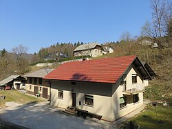
Reka (Slovene pronunciation: [ˈɾeːka]) is a former settlement in the Municipality of Moravče in central Slovenia. It is now part of the village of Gora pri Pečah. The area is part of the traditional region of Upper Carniola. The municipality is now included in the Central Slovenia Statistical Region.
Geography
Reka lies along Drtijščica Creek, north of the main road from Moravče to Mlinše.
History
Reka had a population of 17 living in two houses in 1900. Reka was annexed by Gora pri Pečah (at that time still called Gora svetega Florjana) in 1952, ending its existence as an independent settlement.
References
- Savnik, Roman (1971). Krajevni leksikon Slovenije, vol. 2. Ljubljana: Državna založba Slovenije. p. 86.
- Topole, Maja (2003). Geografija občine Moravče. Ljubljana: Založba ZRC. p. 193.
- Moravče municipal site
- Leksikon občin kraljestev in dežel zastopanih v državnem zboru, vol. 6: Kranjsko. Vienna: C. Kr. Dvorna in Državna Tiskarna. 1906. p. 21.
- Cerovac, Peter (1973). Seznam sprememb naselij SR Slovenije od leta 1948 do 1972: preimenovanja, pristavki, združitve, razdružitve in razglasitve. Ljubljana: Zavod SR Slovenije za statistiko. pp. 27, 67.
External links
 Media related to Reka at Wikimedia Commons
- Reka on Geopedia
This article about the Municipality of Moravče in Slovenia is a stub. You can help Misplaced Pages by expanding it. |
