| Resolute Mountain | |
|---|---|
| Lion Peak | |
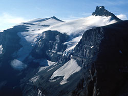
 Resolute Mountain from the North, 2017 Resolute Mountain from the North, 2017 | |
| Highest point | |
| Elevation | 3,150 m (10,330 ft) |
| Prominence | 395 m (1,296 ft) |
| Parent peak | Mount Cline (3361 m) |
| Listing | Mountains of Alberta |
| Coordinates | 52°04′24″N 116°39′34″W / 52.07333°N 116.65944°W / 52.07333; -116.65944 |
| Geography | |
 | |
| Country | Canada |
| Province | Alberta |
| Parent range | Cline Range |
| Topo map | NTS 83C2 Cline River |
| Climbing | |
| First ascent | 1958 A. Hober, E. Hopkins, D.G. Linke |
Resolute Mountain is located in David Thompson Country, western Alberta, Canada, 12 km north of Saskatchewan River Crossing. Its line parent is Mount Cline located 2 kilometres to the east.
Resolute has two main peaks, Lion and Lioness. They are each about 3150 m high. Both peaks are glaciated on their northern slopes. Resolute was first ascended in 1958 by A. Hober and E. Hopkins. The easiest route up Resolute is accessible from Alberta Highway 11, where it crosses Thompson creek.
References
- ^ "Resolute Mountain". cdnrockiesdatabases.ca. Retrieved 2017-08-13.
- "Topographic map of Resolute Mountain". opentopomap.org. Retrieved 2021-10-24.
- ^ "Resolute Mountain". peakery.com. Retrieved 2017-08-13.
- ^ "Lion Peak (Resolute Mountain)". Bivouac.com. Retrieved 2021-10-24.
- ^ "Resolute Mountain". Geographical Names Data Base. Natural Resources Canada. Retrieved 2021-10-24.
- "Cline Range". Peakbagger.com. Retrieved 2017-08-12.
- "Environmentally Significant Areas Inventory of the Rocky Mountain Natural Region of Alberta" (PDF). p. 36.
- Ross, Jane; Kyba, Daniel (2016-03-02). The David Thompson Highway Hiking Guide – 2nd Edition. Rocky Mountain Books Ltd. ISBN 9781771600910.